IMAGES TAKEN NEAR TO
High Road, BASILDON, SS13 3BY
Introduction
This page details the photographs taken nearby to High Road, SS13 3BY by members of the Geograph project.
The Geograph project started in 2005 with the aim of publishing, organising and preserving representative images for every square kilometre of Great Britain, Ireland and the Isle of Man.

There are currently over 7.5m images from over14,400 individuals and you can help contribute to the project by visiting https://www.geograph.org.uk
Image Map
Images are licensed for reuse under creativecommons.org/licenses/by-sa/2.0
Notes
- Clicking on the map will re-center to the selected point.
- The higher the marker number, the further away the image location is from the centre of the postcode.
Image Listing (34 Images Found)
Images are licensed for reuse under creativecommons.org/licenses/by-sa/2.0
Image
Details
Distance
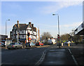
1
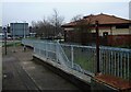
Station Lane Underpass
Looking towards the High Road.
Image: © Paul Francis
Taken: 24 Mar 2001
0.06 miles
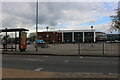
4
The New Station Lane, Looking Towards Pitsea Flyover
Image: © Paul Francis
Taken: 24 Mar 2001
0.08 miles
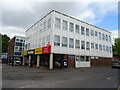
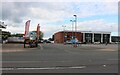
5
Pitsea, Essex
Looking east towards Bowers Gifford Road
Image: © John Winfield
Taken: 9 Dec 2005
0.09 miles
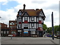
6
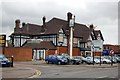
The Railway Public House, Pitsea
The Railway is now closed and securely boarded up - awaiting demolition?
Image: © Trevor Harris
Taken: 7 Oct 2008
0.09 miles
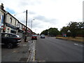
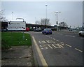
10
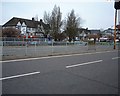
Station Lane
Looking towards The Railway Hotel (right of centre)
Image: © Paul Francis
Taken: 24 Mar 2001
0.10 miles