IMAGES TAKEN NEAR TO
High Road, BASILDON, SS13 3BW
Introduction
This page details the photographs taken nearby to High Road, SS13 3BW by members of the Geograph project.
The Geograph project started in 2005 with the aim of publishing, organising and preserving representative images for every square kilometre of Great Britain, Ireland and the Isle of Man.

There are currently over 7.5m images from over14,400 individuals and you can help contribute to the project by visiting https://www.geograph.org.uk
Image Map
Images are licensed for reuse under creativecommons.org/licenses/by-sa/2.0
Notes
- Clicking on the map will re-center to the selected point.
- The higher the marker number, the further away the image location is from the centre of the postcode.
Image Listing (29 Images Found)
Images are licensed for reuse under creativecommons.org/licenses/by-sa/2.0
Image
Details
Distance
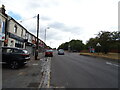
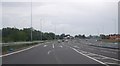
6
Station Lane Underpass
Looking towards the High Road.
Image: © Paul Francis
Taken: 24 Mar 2001
0.12 miles
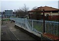
7
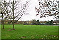
Howards Park
This is a view of the park taken by Image
Image: © terry joyce
Taken: 13 Nov 2010
0.12 miles
8
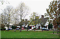
Chimney Sweeps Heaven
These houses with impressive chimneys are in Howard Crescent on the North side of Howards Park.
Image: © terry joyce
Taken: 13 Nov 2010
0.15 miles
9
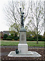
Pitsea War Memorial
The memorial is inscribed on all four sides. This is the side looking East.
See Image for more information.
Image: © terry joyce
Taken: 13 Nov 2010
0.15 miles
10
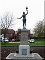
Pitsea War Memorial
The memorial is inscribed on all four sides. This is the side looking North.
See Image for more information.
Image: © terry joyce
Taken: 13 Nov 2010
0.15 miles