IMAGES TAKEN NEAR TO
Elm Road, BASILDON, SS13 2LY
Introduction
This page details the photographs taken nearby to Elm Road, SS13 2LY by members of the Geograph project.
The Geograph project started in 2005 with the aim of publishing, organising and preserving representative images for every square kilometre of Great Britain, Ireland and the Isle of Man.

There are currently over 7.5m images from over14,400 individuals and you can help contribute to the project by visiting https://www.geograph.org.uk
Image Map
Images are licensed for reuse under creativecommons.org/licenses/by-sa/2.0
Notes
- Clicking on the map will re-center to the selected point.
- The higher the marker number, the further away the image location is from the centre of the postcode.
Image Listing (7 Images Found)
Images are licensed for reuse under creativecommons.org/licenses/by-sa/2.0
Image
Details
Distance
1
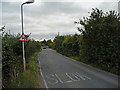
Burnt Mills Road
Leading from Basildon towards North Benfleet.
Fast two way traffic, blind bends, no pavements or verges. A really bad place for an evening stroll.
Image: © John Allan
Taken: 20 Sep 2011
0.15 miles
2
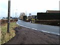
Burnt Mills Rd
This is Burnt Mills Road on the edge of Basildon, the photo was taken looking eastbound towards Pound Lane
Image: © Glyn Baker
Taken: 21 Feb 2006
0.15 miles
3
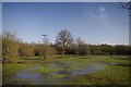
Flooded Paddock in Nevendon
This paddock beside Image is distinctly damp!
Image: © Glyn Baker
Taken: 17 Feb 2013
0.15 miles
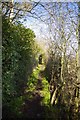
4
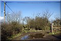
Footpath 143
This is the point where Image ends and Footpath 143 begins
Image: © Glyn Baker
Taken: 17 Feb 2013
0.17 miles
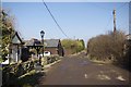
5
Towards Burnt Mills Road
This is footpath 143 in Basildon
Image: © Glyn Baker
Taken: 17 Feb 2013
0.18 miles
6
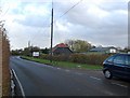
Burnt Mills Road, Nevendon
The buildings here house a nursery and pre-school. In a former incarnation they were part of a different kind of nursery as Basildon Rose Gardens.
Image: © Trevor Harris
Taken: 14 Nov 2009
0.19 miles
7
Upper Avenue North Benfleet
Upper Avenue is a private road but is Image
Image: © Glyn Baker
Taken: 17 Feb 2013
0.21 miles