IMAGES TAKEN NEAR TO
Clarence Road, BASILDON, SS13 2JW
Introduction
This page details the photographs taken nearby to Clarence Road, SS13 2JW by members of the Geograph project.
The Geograph project started in 2005 with the aim of publishing, organising and preserving representative images for every square kilometre of Great Britain, Ireland and the Isle of Man.

There are currently over 7.5m images from over14,400 individuals and you can help contribute to the project by visiting https://www.geograph.org.uk
Image Map
Images are licensed for reuse under creativecommons.org/licenses/by-sa/2.0
Notes
- Clicking on the map will re-center to the selected point.
- The higher the marker number, the further away the image location is from the centre of the postcode.
Image Listing (5 Images Found)
Images are licensed for reuse under creativecommons.org/licenses/by-sa/2.0
Image
Details
Distance
1
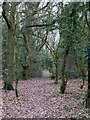
Public Woodland?
There is a path in this small piece of woodland in Bowers Gifford but it is not a footpath shown on the OS map.
Image: © terry joyce
Taken: 11 Jan 2012
0.08 miles
2
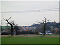
Woodland View
Looking across this farmland on the edge of this grid towards some of the A130 improvement works.
Taken from a small piece of woodland in Bowers Gifford.
Image: © terry joyce
Taken: 11 Jan 2012
0.10 miles
3
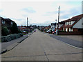
Page Road
This is the top of Page Road a no through road looking to the access from Pound Lane.
Image: © terry joyce
Taken: 11 Jan 2012
0.13 miles
4
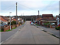
Page Road
Page Road is a no through road accessed from Pound Lane.
Image: © terry joyce
Taken: 11 Jan 2012
0.15 miles
5
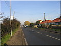
Pound Lane, North Benfleet
Looking north in direction of Wickford
Image: © John Winfield
Taken: 9 Dec 2005
0.24 miles