IMAGES TAKEN NEAR TO
Highlands Crescent, BASILDON, SS13 2JB
Introduction
This page details the photographs taken nearby to Highlands Crescent, SS13 2JB by members of the Geograph project.
The Geograph project started in 2005 with the aim of publishing, organising and preserving representative images for every square kilometre of Great Britain, Ireland and the Isle of Man.

There are currently over 7.5m images from over14,400 individuals and you can help contribute to the project by visiting https://www.geograph.org.uk
Image Map
Images are licensed for reuse under creativecommons.org/licenses/by-sa/2.0
Notes
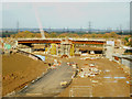
- Clicking on the map will re-center to the selected point.
- The higher the marker number, the further away the image location is from the centre of the postcode.
Image Listing (16 Images Found)
Images are licensed for reuse under creativecommons.org/licenses/by-sa/2.0
Image
Details
Distance
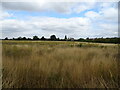
1
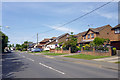
Houses on Pound Lane, Bowers Gifford
Houses only on the east side of the road at first.
Image: © Robin Webster
Taken: 28 May 2017
0.11 miles
2
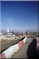
Saddler's Farm Improvements Depot
There was a mad rush to get the A13/A130 junction functioning for the 2012 Olympiad. The road itself was completed so that Mountain Bikers, officials and spectators could get to the Image however there is still quite a bit of work to do to finally finish the whole project.
Image: © Glyn Baker
Taken: 17 Feb 2013
0.12 miles
3
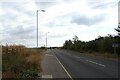
London Road, Bowers Gifford
B1464 towards Southend.
Image: © JThomas
Taken: 23 Aug 2022
0.14 miles
4
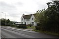
Sadlers Cottages, North Benfleet
This pair of cottages would have housed workers at the nearby (former) farm - Sadlers Farm. The cottages may be threatened by the possible redevelopment of the traffic roundabout at Sadlers Farm.
Image: © Trevor Harris
Taken: 7 Oct 2008
0.16 miles
6
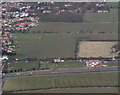
Aerial view
The houses to the right of the pylon are Image and have now been demolished as part of the junction improvement work for Sadlers Farm roundabout.
The field above them is now housing portacabins of the contractors carrying out the improvements.
Image: © terry joyce
Taken: 6 Mar 2009
0.18 miles
7
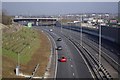
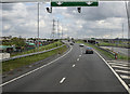
A13 to A130 Interchange
The notorious Image no longer exists, now the junction is much more complicated! However if you get in the right lane your journey should be much faster. If you don't pay attention to lane discipline you can end up on Canvey Island weather you like it or not!! This is the new A13/A130 junction looking towards the A127.
Image: © Glyn Baker
Taken: 17 Feb 2013
0.18 miles
9
Sadler's Farm
This construction will be part the A13 to A130 underpass at Sadler's Farm. Taken from theImage on the B1464 London Road that spans the underpass, looking north.
Image: © terry joyce
Taken: 3 Dec 2011
0.19 miles
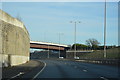
10
Leaving the A13
The last vestiges of the A13 which continues from the outskirts of Benfleet as the A130. This slip takes traffic over the carriageway connecting to the A130 for Chelmsford and connects with a roundabout to give access to the southern end of the A130 for Canvey Island. It also gives access to South Benfleet and Thundersley.
Image: © Martin Addison
Taken: 25 Apr 2015
0.20 miles