IMAGES TAKEN NEAR TO
Scimitar Park Industrial Estate, Courtauld Road, BASILDON, SS13 1ND
Introduction
This page details the photographs taken nearby to Scimitar Park Industrial Estate, Courtauld Road, SS13 1ND by members of the Geograph project.
The Geograph project started in 2005 with the aim of publishing, organising and preserving representative images for every square kilometre of Great Britain, Ireland and the Isle of Man.

There are currently over 7.5m images from over14,400 individuals and you can help contribute to the project by visiting https://www.geograph.org.uk
Image Map
Images are licensed for reuse under creativecommons.org/licenses/by-sa/2.0
Notes
- Clicking on the map will re-center to the selected point.
- The higher the marker number, the further away the image location is from the centre of the postcode.
Image Listing (4 Images Found)
Images are licensed for reuse under creativecommons.org/licenses/by-sa/2.0
Image
Details
Distance
1
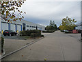
Scimitar Park
Industrial and warehouse units on the eastern outskirts of Basildon.
Image: © John Allan
Taken: 26 Oct 2010
0.03 miles
3
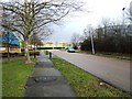
Wollaston Way
These brightly coloured industrial units are in Wollaston Way part of the Burnt Mills industrial area of Basildon. The road to the left is Rowhedge Close, the photo was taken looking east.
Image: © Glyn Baker
Taken: 21 Feb 2006
0.15 miles
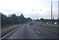
4
A127 Southend Arterial Road
Towards Southend, a 1930s state-of-the-art trunk road, rather modified now - e.g. deceleration lanes.
Image: © Robin Webster
Taken: 9 May 2021
0.19 miles