IMAGES TAKEN NEAR TO
Manilla Road, SOUTHEND-ON-SEA, SS1 2TS
Introduction
This page details the photographs taken nearby to Manilla Road, SS1 2TS by members of the Geograph project.
The Geograph project started in 2005 with the aim of publishing, organising and preserving representative images for every square kilometre of Great Britain, Ireland and the Isle of Man.

There are currently over 7.5m images from over14,400 individuals and you can help contribute to the project by visiting https://www.geograph.org.uk
Image Map
Images are licensed for reuse under creativecommons.org/licenses/by-sa/2.0
Notes
- Clicking on the map will re-center to the selected point.
- The higher the marker number, the further away the image location is from the centre of the postcode.
Image Listing (91 Images Found)
Images are licensed for reuse under creativecommons.org/licenses/by-sa/2.0
Image
Details
Distance
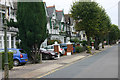
1
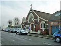
Southchurch Park Congregational Church
On Northumberland Avenue.
Image: © Robin Webster
Taken: 12 Dec 2013
0.09 miles
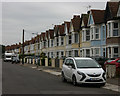
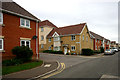
3

Southchurch Park - NW corner
The houses are on Northumberland Crescent.
Image: © Robin Webster
Taken: 12 Dec 2013
0.14 miles
4
Victoria Road, Southend
Taken from the corner of Retort Close looking north.
Image: © David Kemp
Taken: 15 Sep 2013
0.14 miles
5

A vacant plot on the Eastern Esplanade
Image: © Roger A Smith
Taken: 23 Feb 2017
0.16 miles
7
Kensington Road, Southend
First floor balconies have long been a feature of Southend's suburban scene, even when they don't afford sea views.
Image: © David Kemp
Taken: 15 Sep 2013
0.17 miles
8
Junction of Victoria Road & Retort Close, Southend
Retort Close is presumably so named because it forms part of the redevelopment of the former gasworks site which closed in 1968.
Image: © David Kemp
Taken: 15 Sep 2013
0.17 miles
9
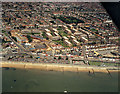
Aerial view of Southend seafront: east of the pier
This view covers the seafront just east of the pier. The main road joining the seafront at the left is Southchurch Avenue. Just above right of this is the Kursaal, now a shadow of what it was in 1988 (when this was taken). The area below this in the photo (below the esplanade) is now occupied by the Sea Life Centre Image
This is the first in a series of views of the seafront from the south (sea) side. The next one (to the west) is Image
Image: © Edward Clack
Taken: 26 May 1988
0.18 miles
10
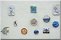
South End Plaques
Ceramic art on Southend sea front
Image: © Glyn Baker
Taken: 29 Jul 2011
0.18 miles