
IMAGES TAKEN NEAR TO
Kursaal Way, SOUTHEND-ON-SEA, SS1 2SU
Introduction
This page details the photographs taken nearby to Kursaal Way, SS1 2SU by members of the Geograph project.
The Geograph project started in 2005 with the aim of publishing, organising and preserving representative images for every square kilometre of Great Britain, Ireland and the Isle of Man.

There are currently over 7.5m images from over14,400 individuals and you can help contribute to the project by visiting https://www.geograph.org.uk
Image Map
Images are licensed for reuse under creativecommons.org/licenses/by-sa/2.0
Notes
- Clicking on the map will re-center to the selected point.
- The higher the marker number, the further away the image location is from the centre of the postcode.
Image Listing (91 Images Found)
Images are licensed for reuse under creativecommons.org/licenses/by-sa/2.0
Image
Details
Distance
1
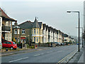
Turreted house on Woodgrange Drive
A turret for the house on the corner is not an uncommon feature of housing development of this sort of age.
Image: © Robin Webster
Taken: 12 Dec 2013
0.12 miles
4
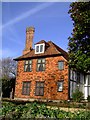
Southchurch Hall, rear
Dating back to the late 13th/early 14th century.
Image: © Julieanne Savage
Taken: 14 Jan 2007
0.16 miles
5
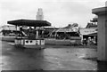
Southend Kursaal in 1964
In 1964 The Kursaal was home to an outdoor funfair area.
Image: © Clint Mann
Taken: Unknown
0.16 miles
6
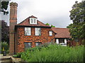
Southend: Southchurch Hall
This is the rear of the manor house with the chimney on the left being the chimney on the right in Image
Image: © Nigel Cox
Taken: 22 Jun 2007
0.16 miles
7
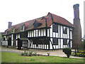
Southend: Southchurch Hall
Southchurch Hall is a moated medieval manor house surrounded by earthworks. It comprises a late 13th or early 14th century timber framed building with a central hall open to the roof, which is to the left of the photo, and an extension on its west side dating from around 1560 to the right.
Throughout the medieval period the Hall and its land was owned by Christ Church, Canterbury. In the early 1920s it was operating as a farm but was under serious threat of destruction from the rapid expansion of Southend. Fortunately, a group of individuals actively sought to preserve the threatened building and its earthworks. The Hall was eventually presented to Southend Borough Council by its then owners, the Dowsett family. It was extensively but sensitively restored in the late 1920s and opened to the public as a branch library in 1931 with the earthworks forming part of a public park.
Following local government reorganisation in 1974, when libraries were placed under the control of Essex County Council, the Hall was converted to museum use, which it is used for today. It is also now a non-religious wedding ceremony venue.
Image: © Nigel Cox
Taken: 22 Jun 2007
0.16 miles
8
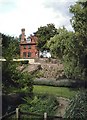
Southchurch Hall
Southchurch Hall, now a museum, stands in a delightful little park almost hidden by the surrounding terraced streets.
Image: © John Myers
Taken: 30 Aug 2006
0.16 miles
9
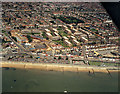
Aerial view of Southend seafront: east of the pier
This view covers the seafront just east of the pier. The main road joining the seafront at the left is Southchurch Avenue. Just above right of this is the Kursaal, now a shadow of what it was in 1988 (when this was taken). The area below this in the photo (below the esplanade) is now occupied by the Sea Life Centre Image
This is the first in a series of views of the seafront from the south (sea) side. The next one (to the west) is Image
Image: © Edward Clack
Taken: 26 May 1988
0.17 miles
10
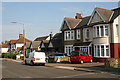
York Road, Southchurch
The further east you go along York Road, the newer the houses become. The two semis nearest the camera date from around the time of the First World War and those beyond from a bit later. The mixture of semis and bungalows in the same block seems very characteristic of the C20 development of Southend. This shot was taken between Cheltenham Road and Leamington Road.
Image: © David Kemp
Taken: 8 Aug 2013
0.18 miles