IMAGES TAKEN NEAR TO
Mayfair Place, SOUTHEND-ON-SEA, SS1 2FR
Introduction
This page details the photographs taken nearby to Mayfair Place, SS1 2FR by members of the Geograph project.
The Geograph project started in 2005 with the aim of publishing, organising and preserving representative images for every square kilometre of Great Britain, Ireland and the Isle of Man.

There are currently over 7.5m images from over14,400 individuals and you can help contribute to the project by visiting https://www.geograph.org.uk
Image Map
Images are licensed for reuse under creativecommons.org/licenses/by-sa/2.0
Notes
- Clicking on the map will re-center to the selected point.
- The higher the marker number, the further away the image location is from the centre of the postcode.
Image Listing (92 Images Found)
Images are licensed for reuse under creativecommons.org/licenses/by-sa/2.0
Image
Details
Distance
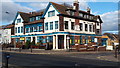
2
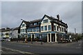
The Castle
Alas, now closed and up for sale - a victim of Covid 19 restrictions perhaps?
Image: © John Myers
Taken: 30 Oct 2020
0.05 miles
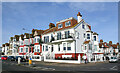
3
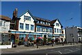
The Castle, Southend On Sea
On Eastern Esplanade.
Image: © JThomas
Taken: 23 Aug 2022
0.05 miles
4
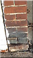
Ordnance Survey Bench Mark
Mark located on a wall that forms part of The Castle Hotel boundary. These marks were used by Ordnance Survey for mapping purposes.
Image: © V1ncenze
Taken: 1 Dec 2019
0.06 miles
5
The Castle Hotel, Eastern Esplanade, Southend-on-Sea
Image: © V1ncenze
Taken: 1 Dec 2019
0.06 miles
6
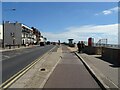
National Cycle Route 16, Southend-on-Sea
Beside Eastern Esplanade (B1016).
Image: © JThomas
Taken: 23 Aug 2022
0.06 miles
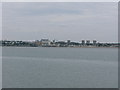
7
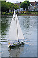
Messing about on the water
Model yacht in Southchurch park.
Image: © william
Taken: 5 Jun 2010
0.07 miles
8
Eastern Esplanade (left) & Chelsea Avenue (right), Southend
Image: © David Kemp
Taken: 5 Feb 2023
0.07 miles
9
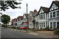
Shaftesbury Avenue, Southend
Long straight roads of fairly substantial terraced housing such as this are typical of many of the older parts of Southend. Shaftesbury Avenue, seen here looking east, faces Southchurch Park. Compared with the picture I took of it in 2006 Image the road seems to have improved over the intervening years.
Image: © David Kemp
Taken: 15 Sep 2013
0.07 miles
10
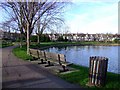
Southchurch Park lake
People sail remote control boats here.
Image: © Julieanne Savage
Taken: 14 Jan 2007
0.07 miles