IMAGES TAKEN NEAR TO
Kilworth Avenue, SOUTHEND-ON-SEA, SS1 2DS
Introduction
This page details the photographs taken nearby to Kilworth Avenue, SS1 2DS by members of the Geograph project.
The Geograph project started in 2005 with the aim of publishing, organising and preserving representative images for every square kilometre of Great Britain, Ireland and the Isle of Man.

There are currently over 7.5m images from over14,400 individuals and you can help contribute to the project by visiting https://www.geograph.org.uk
Image Map
Images are licensed for reuse under creativecommons.org/licenses/by-sa/2.0
Notes
- Clicking on the map will re-center to the selected point.
- The higher the marker number, the further away the image location is from the centre of the postcode.
Image Listing (30 Images Found)
Images are licensed for reuse under creativecommons.org/licenses/by-sa/2.0
Image
Details
Distance
1
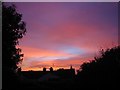
Sunset over Southend town centre
This was taken from my back garden.
Image: © lesley fowler
Taken: 5 Nov 2006
0.12 miles
2
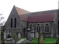
St. John's
This centralised church has been targeted for "development" as part of the Pier / Palace Hotel refurbishments. It stands next to the Palace Hotel.
http://www.echo-news.co.uk/display.var.1096397.0.revamp_shows_off_church_treasures.php
Image: © Julieanne Savage
Taken: 12 Jan 2007
0.13 miles
4
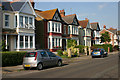
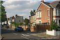
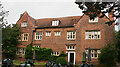
York Road, Southchurch
This part of York Road - between Honiton Road and Cheltenham Road - was built at the turn of the C19/C20 with fairly large semi-detached properties such as these, many of which are now multi-occupied. Before its connection with Southend High Street was severed several decades ago, York Road was a busy through route between Southend and Thorpe Bay and enjoyed a frequent bus service.
Image: © David Kemp
Taken: 8 Aug 2013
0.18 miles
5
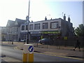
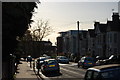
North-east corner of York Road & Cheltenham Road, Southchurch
Taken from York Road looking up Cheltenham Road.
Image: © David Kemp
Taken: 8 Aug 2013
0.18 miles
6
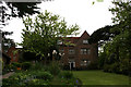
Porters, The Garden
The Mayors Official Residence, Southchurch, Southend.
Image: © terry joyce
Taken: 16 May 2010
0.18 miles
7
Porters, The Mayors Official Residence.
Located in Southchurch,Southend.
Image: © terry joyce
Taken: 16 May 2010
0.19 miles
8
Honiton Road, Southchurch
A view down Honiton Road with the dome of the Kursaal in the background.
Image: © Trevor Harris
Taken: 30 Nov 2011
0.20 miles
9
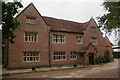
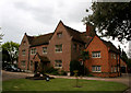
Porters, Southchurch Road, Southend (north elevation)
Most of the building dates from c.1600. It was sold in 1932 to Southend Corporation by its then owner, Sir Charles Nicholson. Sometimes known today as Civic House, it houses the Mayor's Parlour and is used for ceremonial and public events.
Image: © David Kemp
Taken: 20 Sep 2021
0.21 miles
10
Porters, Southchurch Road, Southend (south elevation)
Most of the building dates from c.1600. It was sold in 1932 to Southend Corporation by its then owner, Sir Charles Nicholson. Sometimes known today as Civic House, it houses the Mayor's Parlour and is used for ceremonial and public events.
Image: © David Kemp
Taken: 20 Sep 2021
0.21 miles