IMAGES TAKEN NEAR TO
Arterial Road, SS12 9SN
Introduction
This page details the photographs taken nearby to Arterial Road, SS12 9SN by members of the Geograph project.
The Geograph project started in 2005 with the aim of publishing, organising and preserving representative images for every square kilometre of Great Britain, Ireland and the Isle of Man.

There are currently over 7.5m images from over14,400 individuals and you can help contribute to the project by visiting https://www.geograph.org.uk
Image Map
Images are licensed for reuse under creativecommons.org/licenses/by-sa/2.0
Notes
- Clicking on the map will re-center to the selected point.
- The higher the marker number, the further away the image location is from the centre of the postcode.
Image Listing (12 Images Found)
Images are licensed for reuse under creativecommons.org/licenses/by-sa/2.0
Image
Details
Distance

3
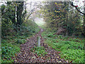
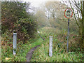
Pathway or Road?
I believe this pathway was once a road. There are sections with tarmac under the mud and grass. It goes to Harrow Road and Bridleway 150.
It is accessed from the cycle path on the London bound carriageway of the A127.
Image: © terry joyce
Taken: 19 Nov 2010
0.09 miles
4
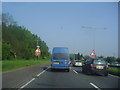
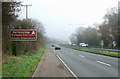
Traffic waiting on the A127, North Benfleet
'A postcard from Essex'
Image: © David Howard
Taken: 24 May 2012
0.10 miles
6
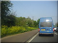
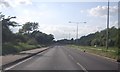
Arterial Cycle Path
This is the A127 Southend bound and the Cycle Path.
Image: © terry joyce
Taken: 19 Nov 2010
0.11 miles
7
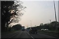
Start or End?
This is the opposite end of the pathway to Image
Image: © terry joyce
Taken: 19 Nov 2010
0.13 miles
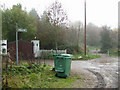
9
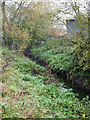
Parallel Stream
This stream runs parallel with Image
Image: © terry joyce
Taken: 19 Nov 2010
0.15 miles
10
Road/Bridleway Junction
This is the end of Harrow Road leading into Bridleway 150.
Image: © terry joyce
Taken: 19 Nov 2010
0.20 miles