IMAGES TAKEN NEAR TO
North Benfleet Hall Road, WICKFORD, SS12 9JR
Introduction
This page details the photographs taken nearby to North Benfleet Hall Road, SS12 9JR by members of the Geograph project.
The Geograph project started in 2005 with the aim of publishing, organising and preserving representative images for every square kilometre of Great Britain, Ireland and the Isle of Man.

There are currently over 7.5m images from over14,400 individuals and you can help contribute to the project by visiting https://www.geograph.org.uk
Image Map
Images are licensed for reuse under creativecommons.org/licenses/by-sa/2.0
Notes
- Clicking on the map will re-center to the selected point.
- The higher the marker number, the further away the image location is from the centre of the postcode.
Image Listing (6 Images Found)
Images are licensed for reuse under creativecommons.org/licenses/by-sa/2.0
Image
Details
Distance
1
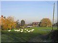
North Benfleet Hall Farm, Essex
Although this looks more like a village green, it is in fact part of the farm.
Image: © John Winfield
Taken: 9 Dec 2005
0.12 miles
2
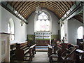
North Benfleet Church
Interior of chancel from the west
Image: © John Vigar
Taken: 16 Sep 2010
0.13 miles
3
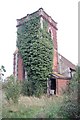
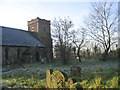
North Benfleet Church
Unvisited and uncared for the church presents a sorry state.
Image: © Trevor Harris
Taken: 4 Oct 2008
0.15 miles
5
Parish Church, North Benfleet
A redundant church and one that sadly looks very run down and neglected.
Image: © John Winfield
Taken: 9 Dec 2005
0.18 miles
6
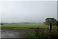
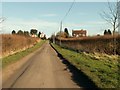
Bridleway Junction
I'm standing at the junction of the bridleway with an unmade road which is access to North Benfleet Hall Lake, so it is possible to get cars driving across the bridleway. The lake is approximately 70 metres behind me.
It was a bit of a misty day, but the buildings are part of North Benfleet Hall Farm.
Image: © terry joyce
Taken: 19 Nov 2010
0.20 miles