IMAGES TAKEN NEAR TO
Nevendon Road, WICKFORD, SS12 0NX
Introduction
This page details the photographs taken nearby to Nevendon Road, SS12 0NX by members of the Geograph project.
The Geograph project started in 2005 with the aim of publishing, organising and preserving representative images for every square kilometre of Great Britain, Ireland and the Isle of Man.

There are currently over 7.5m images from over14,400 individuals and you can help contribute to the project by visiting https://www.geograph.org.uk
Image Map
Images are licensed for reuse under creativecommons.org/licenses/by-sa/2.0
Notes
- Clicking on the map will re-center to the selected point.
- The higher the marker number, the further away the image location is from the centre of the postcode.
Image Listing (4 Images Found)
Images are licensed for reuse under creativecommons.org/licenses/by-sa/2.0
Image
Details
Distance
1
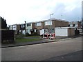
Thackeray Row, Wickford
These flat roofed early 1970’s(?) houses are in Thackeray Row, Wickford.
Image: © Glyn Baker
Taken: 24 Feb 2006
0.14 miles
2
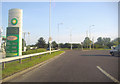
Roundabout on Golden Jubilee Way, Wickford
Image: © David Howard
Taken: 20 Jun 2012
0.23 miles
4
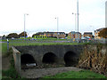
Three Culverts
The OS map shows this being fed from South West of this roundabout on the A132.
Looking at the size of these culverts, they are probably fed from local rain drains as well. it would be interesting to see the flow in heavy rain. They feed into a relatively narrow stream that joins the River Crouch near the roundabout where the A132, joins the A129.
See Image, Image and Image
Image: © terry joyce
Taken: 22 Nov 2010
0.25 miles