IMAGES TAKEN NEAR TO
Studland Avenue, WICKFORD, SS12 0JP
Introduction
This page details the photographs taken nearby to Studland Avenue, SS12 0JP by members of the Geograph project.
The Geograph project started in 2005 with the aim of publishing, organising and preserving representative images for every square kilometre of Great Britain, Ireland and the Isle of Man.

There are currently over 7.5m images from over14,400 individuals and you can help contribute to the project by visiting https://www.geograph.org.uk
Image Map
Images are licensed for reuse under creativecommons.org/licenses/by-sa/2.0
Notes
- Clicking on the map will re-center to the selected point.
- The higher the marker number, the further away the image location is from the centre of the postcode.
Image Listing (8 Images Found)
Images are licensed for reuse under creativecommons.org/licenses/by-sa/2.0
Image
Details
Distance
1
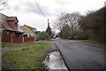
Banksome Avenue Wickford
The chalet style houses in this area indicate it may have developed from a former "plotland" development. For more info on plotlands go to Image
Image: © Glyn Baker
Taken: 7 Feb 2013
0.17 miles
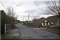
2
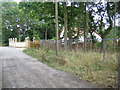
Wickford: Plotland
This is Studland Avenue which runs through the centre of a plotland development.
Plotlands originated from the arrival of the railways in the 19th century, which improved the accessibility of the Essex countryside to city dwellers from London. Farmers and other landowners divided their fields into narrow plots, which city dwellers bought and proceeded to build small shacks and dwellings that they could visit at weekends and on holiday to get away from London. Most of these properties did not have the benefits of running water, sewage disposal or electricity and were located down unmade tracks, sometimes miles from any services. They have a semi-rural character that is still typified by privately maintained roads, varying dwelling plot sizes, natural property boundaries and vacant plots. (Information (with spelling and grammar corrections!) from Basildon Council's website http://www.basildon.gov.uk/index.aspx?articleid=2191
In this photo there is a substantial well-maintained modern house next to a vacant plot aptly called "The Wilderness". Elsewhere on the site there are examples of much earlier and much smaller houses. The roads are all named after holiday destinations in Dorset, others being Branksome, Boscombe, Christchurch, etc..
Image: © Nigel Cox
Taken: 15 Aug 2006
0.17 miles
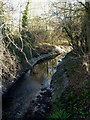
3
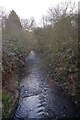
Down Stream on The River Crouch
Image: © Glyn Baker
Taken: 7 Feb 2013
0.19 miles
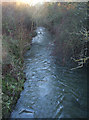
4
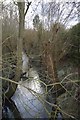
Upstream on The River Crouch
Pollarded Willows stand beside the river. You can also see Image
Image: © Glyn Baker
Taken: 7 Feb 2013
0.19 miles
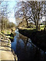
5
River Crouch
This is the River Crouch flowing towards Wickford after it has just passed under Castledon Road.
Image: © terry joyce
Taken: 16 Jan 2012
0.19 miles
7
River Crouch
This is the River Crouch and at this point it is running parallel to Footpath 91 from Castledon Road.
Image: © terry joyce
Taken: 16 Jan 2012
0.22 miles
8
Sugden Rd Wickford
Image: © Glyn Baker
Taken: 7 Feb 2013
0.24 miles