IMAGES TAKEN NEAR TO
The Tithe, WICKFORD, SS12 0HN
Introduction
This page details the photographs taken nearby to The Tithe, SS12 0HN by members of the Geograph project.
The Geograph project started in 2005 with the aim of publishing, organising and preserving representative images for every square kilometre of Great Britain, Ireland and the Isle of Man.

There are currently over 7.5m images from over14,400 individuals and you can help contribute to the project by visiting https://www.geograph.org.uk
Image Map
Images are licensed for reuse under creativecommons.org/licenses/by-sa/2.0
Notes
- Clicking on the map will re-center to the selected point.
- The higher the marker number, the further away the image location is from the centre of the postcode.
Image Listing (3 Images Found)
Images are licensed for reuse under creativecommons.org/licenses/by-sa/2.0
Image
Details
Distance
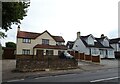
1
Elder Footpath
This footpath from Elder Avenue goes through to Borwick Lane.
Image: © terry joyce
Taken: 16 Jan 2012
0.09 miles
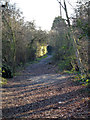
2
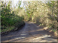
Track continuation of Grange Avenue, Wickford
It is unclear if this is public, there was nothing to say it was not.
Image: © Robin Webster
Taken: 5 Feb 2023
0.17 miles