IMAGES TAKEN NEAR TO
Alma Close, WICKFORD, SS12 0HJ
Introduction
This page details the photographs taken nearby to Alma Close, SS12 0HJ by members of the Geograph project.
The Geograph project started in 2005 with the aim of publishing, organising and preserving representative images for every square kilometre of Great Britain, Ireland and the Isle of Man.

There are currently over 7.5m images from over14,400 individuals and you can help contribute to the project by visiting https://www.geograph.org.uk
Image Map
Images are licensed for reuse under creativecommons.org/licenses/by-sa/2.0
Notes
- Clicking on the map will re-center to the selected point.
- The higher the marker number, the further away the image location is from the centre of the postcode.
Image Listing (5 Images Found)
Images are licensed for reuse under creativecommons.org/licenses/by-sa/2.0
Image
Details
Distance
1
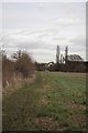
A Healthy Walk?
This footpath is waymarked as one of the Image
Image: © Glyn Baker
Taken: 7 Feb 2013
0.13 miles
2
Elder Footpath
This footpath from Elder Avenue goes through to Borwick Lane.
Image: © terry joyce
Taken: 16 Jan 2012
0.19 miles
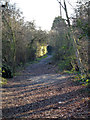
3

Basildon Health Walks
A waymark promoting healthy walking there are a number of circular walks in the district see http://www.basildon.gov.uk/index.aspx?articleid=2423
Image: © Glyn Baker
Taken: 7 Feb 2013
0.20 miles
4
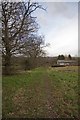
Footpath From Doleshill Farm
This footpath originates at Image and ends just beyond the farm buildings on the A129 London Road.
Image: © Glyn Baker
Taken: 7 Feb 2013
0.20 miles
5
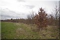
New Plantation in Wickford
A recent plantation of Sessile Oak, Ash, and Hornbeam
Image: © Glyn Baker
Taken: 7 Feb 2013
0.22 miles