IMAGES TAKEN NEAR TO
London Road, WICKFORD, SS12 0AT
Introduction
This page details the photographs taken nearby to London Road, SS12 0AT by members of the Geograph project.
The Geograph project started in 2005 with the aim of publishing, organising and preserving representative images for every square kilometre of Great Britain, Ireland and the Isle of Man.

There are currently over 7.5m images from over14,400 individuals and you can help contribute to the project by visiting https://www.geograph.org.uk
Image Map
Images are licensed for reuse under creativecommons.org/licenses/by-sa/2.0
Notes
- Clicking on the map will re-center to the selected point.
- The higher the marker number, the further away the image location is from the centre of the postcode.
Image Listing (6 Images Found)
Images are licensed for reuse under creativecommons.org/licenses/by-sa/2.0
Image
Details
Distance
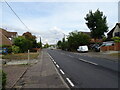
1
Castledon Road bus stops
On London Road, the A129.
Image: © Robin Webster
Taken: 22 Jul 2012
0.13 miles
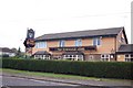
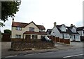
3

The Downham Arms Public House
Originally called The Sorceror when it first opened
Image: © Angela Tuff
Taken: 23 Jan 2006
0.16 miles