IMAGES TAKEN NEAR TO
London Road, WICKFORD, SS12 0AN
Introduction
This page details the photographs taken nearby to London Road, SS12 0AN by members of the Geograph project.
The Geograph project started in 2005 with the aim of publishing, organising and preserving representative images for every square kilometre of Great Britain, Ireland and the Isle of Man.

There are currently over 7.5m images from over14,400 individuals and you can help contribute to the project by visiting https://www.geograph.org.uk
Image Map
Images are licensed for reuse under creativecommons.org/licenses/by-sa/2.0
Notes
- Clicking on the map will re-center to the selected point.
- The higher the marker number, the further away the image location is from the centre of the postcode.
Image Listing (20 Images Found)
Images are licensed for reuse under creativecommons.org/licenses/by-sa/2.0
Image
Details
Distance
1
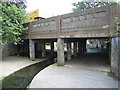
River Crouch in Wickford
This bridge carries the A129 London Road over the river. See Image for an explanation of the width of the concrete conduit that it is flowing in.
Image: © Nigel Cox
Taken: 15 Aug 2006
0.03 miles

3
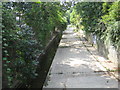
River Crouch in Wickford
Viewed looking upstream from the Nevendon Road bridge, the River Crouch flows in a concrete conduit through the town, with a narrow channel to sustain a reasonable depth of water in ordinary flow conditions and the wide channel to accommodate larger volumes in a flood event.
Image: © Nigel Cox
Taken: 15 Aug 2006
0.08 miles
5
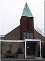
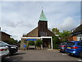
Church of St. Andrew the Apostle
Built originally in 1935, which had to be demolished. The current church on the same site was built in 1964
Image: © Angela Tuff
Taken: 23 Jan 2006
0.09 miles
8

Royal Mail parcel / business postbox on London Road (A129), Wickford
Postbox No. SS12 1139.
Image: © JThomas
Taken: 25 Aug 2022
0.10 miles
9

Elizabeth II postbox on London Road (A129), Wickford
Postbox No. SS12 139.
Image: © JThomas
Taken: 25 Aug 2022
0.10 miles
10
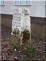
Old Milestone, A129, London Road, Wickford
The milestone is located at the Nevendon Road junction, on a small grass verge at the back of the pavement on the south side of road. Parish of Wickford (Basildon District). Carved stone post, erected by the Rochford Hundred (Division of Essex First District) turnpike trust in the 19th century.
Inscription reads:-
TO / LONDON / 29 MILES / SOUTHEND / 12 MILES / RAYLEIGH / 5 MILES / BILLERICAY / 6 MILES / PARISH OF / WICKFORD
Grade II Listed, List Entry Number: 1122214 https://historicengland.org.uk/listing/the-list/list-entry/1122214
Milestone Society National ID: EX_BWRY29
Image: © JV Nicholls
Taken: 27 Feb 2011
0.13 miles