IMAGES TAKEN NEAR TO
Tangmere Close, WICKFORD, SS11 8XD
Introduction
This page details the photographs taken nearby to Tangmere Close, SS11 8XD by members of the Geograph project.
The Geograph project started in 2005 with the aim of publishing, organising and preserving representative images for every square kilometre of Great Britain, Ireland and the Isle of Man.

There are currently over 7.5m images from over14,400 individuals and you can help contribute to the project by visiting https://www.geograph.org.uk
Image Map
Images are licensed for reuse under creativecommons.org/licenses/by-sa/2.0
Notes
- Clicking on the map will re-center to the selected point.
- The higher the marker number, the further away the image location is from the centre of the postcode.
Image Listing (5 Images Found)
Images are licensed for reuse under creativecommons.org/licenses/by-sa/2.0
Image
Details
Distance
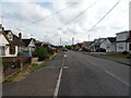
1
Hodgson Way, Shotgate
Shotgate is now an area of housing and business parks on the south eastern side of Wickford.
Image: © Trevor Harris
Taken: 9 Jan 2022
0.13 miles
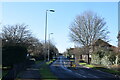
4
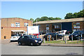
Sopwith Crescent, Shotgate Industrial Estate
A number of roads on the estate have names with aeronautical connections. See my image Image for the reason.
Image: © David Kemp
Taken: 3 Jul 2014
0.23 miles