IMAGES TAKEN NEAR TO
London Road, WICKFORD, SS11 8UA
Introduction
This page details the photographs taken nearby to London Road, SS11 8UA by members of the Geograph project.
The Geograph project started in 2005 with the aim of publishing, organising and preserving representative images for every square kilometre of Great Britain, Ireland and the Isle of Man.

There are currently over 7.5m images from over14,400 individuals and you can help contribute to the project by visiting https://www.geograph.org.uk
Image Map
Images are licensed for reuse under creativecommons.org/licenses/by-sa/2.0
Notes
- Clicking on the map will re-center to the selected point.
- The higher the marker number, the further away the image location is from the centre of the postcode.
Image Listing (31 Images Found)
Images are licensed for reuse under creativecommons.org/licenses/by-sa/2.0
Image
Details
Distance
1
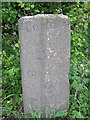
Old Milestone by the A129, London Road, Rawreth Parish
Carved stone post by the A129, in parish of RAWRETH (ROCHFORD District), London Road, 50m West of Rayleigh electrical sub-station, (upturned curbstone) at bus stop by the road, on South side of road. Erected by the Rochford Hundred (Division of Essex First District) turnpike trust in the 19th century.
Inscription reads:-
LONDON
32
SOUTHEND
9
MILES
Milestone Society National ID: EX_BWRY32.
Image: © JV Nicholls
Taken: Unknown
0.02 miles
2
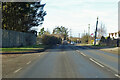
A129 London Road towards Wickford
The name suggests that this was the way from Rayleigh to London before the Southend Arterial Road (A127) of the 1920s.
Image: © Robin Webster
Taken: 5 Feb 2023
0.04 miles
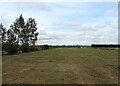
5
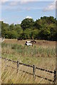
Rawreth Horses
A narrow strip of grazing between the old and the new roads to Chelmsford
Image: © John Myers
Taken: 19 Aug 2010
0.09 miles
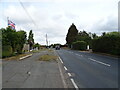
6
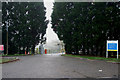
Substation Entrance
This entrance on the A129 leads to Rayleigh Main Substation.
Image
Image: © terry joyce
Taken: 19 Nov 2010
0.09 miles
7
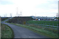
Bridleway Farm Road
This road is the public bridleway and a farm road. It was built when the new A130 was built. A substantial bridge for horses and the occasional farm vehicle has been built over the A130.
Image: © terry joyce
Taken: 18 Nov 2010
0.16 miles
8
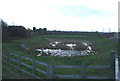
In between Pond
This pond is sandwiched between the A129 and the Bridleway.
Image: © terry joyce
Taken: 18 Nov 2010
0.16 miles
9
Carpenters Arms Pub
Taken from the old Chelmsford Road.
Image: © terry joyce
Taken: 27 Oct 2010
0.16 miles
10
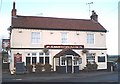
The Carpenters Arms
Pub on the roundabout junction of the A129 and the old A130 west of Rayleigh.
Image: © John Myers
Taken: 21 Jan 2007
0.16 miles