IMAGES TAKEN NEAR TO
Church Road, WICKFORD, SS11 8SQ
Introduction
This page details the photographs taken nearby to Church Road, SS11 8SQ by members of the Geograph project.
The Geograph project started in 2005 with the aim of publishing, organising and preserving representative images for every square kilometre of Great Britain, Ireland and the Isle of Man.

There are currently over 7.5m images from over14,400 individuals and you can help contribute to the project by visiting https://www.geograph.org.uk
Image Map (8 Images)


Getting Data...Please wait
Leaflet Map data © OpenStreetMap
Images are licensed for reuse under creativecommons.org/licenses/by-sa/2.0
Notes
- Clicking on the map will re-center to the selected point.
- The higher the marker number, the further away the image location is from the centre of the postcode.
Image Listing (8 Images Found)
Images are licensed for reuse under creativecommons.org/licenses/by-sa/2.0
Image
Details
Distance
1
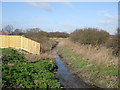
Is this the Crouch?
This seemingly insignificant stream connects to the River Crouch.
Image: © terry joyce
Taken: 4 Mar 2008
0.02 miles
2
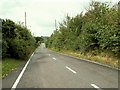
Part of Church Road
This is the section of Church Road that runs by Burrells Farm.
Image: © Robert Edwards
Taken: 13 Aug 2008
0.08 miles
3
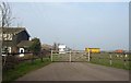
Burrells Farm
Entrance to Burrells Farm on Church Road, Rawreth.
Image: © terry joyce
Taken: 19 Feb 2008
0.13 miles
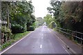
4
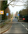
Church Road, Rawreth
Entrance to Church Road, Rawreth
Image: © terry joyce
Taken: 19 Feb 2008
0.16 miles