IMAGES TAKEN NEAR TO
Beauchamps Drive, WICKFORD, SS11 8NF
Introduction
This page details the photographs taken nearby to Beauchamps Drive, SS11 8NF by members of the Geograph project.
The Geograph project started in 2005 with the aim of publishing, organising and preserving representative images for every square kilometre of Great Britain, Ireland and the Isle of Man.

There are currently over 7.5m images from over14,400 individuals and you can help contribute to the project by visiting https://www.geograph.org.uk
Image Map
Images are licensed for reuse under creativecommons.org/licenses/by-sa/2.0
Notes
- Clicking on the map will re-center to the selected point.
- The higher the marker number, the further away the image location is from the centre of the postcode.
Image Listing (4 Images Found)
Images are licensed for reuse under creativecommons.org/licenses/by-sa/2.0
Image
Details
Distance
1
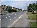
Wickford: Beauchamps Drive
Residential development in the north-east corner of Wickford.
Image: © Nigel Cox
Taken: 15 Aug 2006
0.11 miles
2
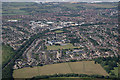
Beauchamps High School
The School is evident because of the playing field.Wickford and Shotgate are the towns shown in the picture.
Image: © terry joyce
Taken: 28 Jun 2010
0.16 miles
4
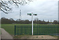
Follow the sign
Wickford Memorial Park.
Very impressive, take a look on Google Earth 51 37 05n, 0 32 16e.
80 acres of parkland,Cricket pitch,Football pitch,Six-rink bowling green
Tennis Court,Basketball Court,Novelty golf,Children's playground, Sports pavilion,Riverside walk,Rose gardens,Small woodland and Memorial Avenue.
Image: © terry joyce
Taken: 2 Apr 2008
0.25 miles