IMAGES TAKEN NEAR TO
Haslemere Road, WICKFORD, SS11 7LA
Introduction
This page details the photographs taken nearby to Haslemere Road, SS11 7LA by members of the Geograph project.
The Geograph project started in 2005 with the aim of publishing, organising and preserving representative images for every square kilometre of Great Britain, Ireland and the Isle of Man.

There are currently over 7.5m images from over14,400 individuals and you can help contribute to the project by visiting https://www.geograph.org.uk
Image Map (Loading...)


Getting Data...Please wait
Leaflet Map data © OpenStreetMap
Images are licensed for reuse under creativecommons.org/licenses/by-sa/2.0
Notes
- Clicking on the map will re-center to the selected point.
- The higher the marker number, the further away the image location is from the centre of the postcode.
Image Listing (2 Images Found)
Images are licensed for reuse under creativecommons.org/licenses/by-sa/2.0
Image
Details
Distance
1
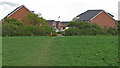
Public footpath through grass field, Wickford
Footpath leading from Downham to Wickford on a piece of open ground near a housing estate, Wickford.
Image: © Roger Jones
Taken: 25 Apr 2015
0.22 miles
2
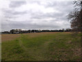
Housing Development?
This piece of land is subject to a local enquiry as developers want to build houses on the site.
Image: © terry joyce
Taken: 29 Dec 2011
0.25 miles