IMAGES TAKEN NEAR TO
Merlin Way, WICKFORD, SS11 7HB
Introduction
This page details the photographs taken nearby to Merlin Way, SS11 7HB by members of the Geograph project.
The Geograph project started in 2005 with the aim of publishing, organising and preserving representative images for every square kilometre of Great Britain, Ireland and the Isle of Man.

There are currently over 7.5m images from over14,400 individuals and you can help contribute to the project by visiting https://www.geograph.org.uk
Image Map (Loading...)


Getting Data...Please wait
Leaflet Map data © OpenStreetMap
Images are licensed for reuse under creativecommons.org/licenses/by-sa/2.0
Notes
- Clicking on the map will re-center to the selected point.
- The higher the marker number, the further away the image location is from the centre of the postcode.
Image Listing (7 Images Found)
Images are licensed for reuse under creativecommons.org/licenses/by-sa/2.0
Image
Details
Distance
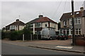
1

Ethelred Gardens, Runwell
The tower and spire of St Mary's Church can be seen in the distance.
Image: © Trevor Harris
Taken: 20 Oct 2014
0.06 miles
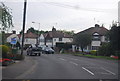
2

Quick Fix Garage on Runwell Road, Wickford
Image: © David Howard
Taken: 13 Apr 2025
0.17 miles
5
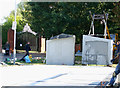
New War Memorial
This is the new War Memorial in Wickford being erected. Each of the pieces being lifted into place weigh 2 ton.
It is located in Memorial Approach.
The gates behind are the North entrance to Memorial Park.
Image: © terry joyce
Taken: 19 Oct 2011
0.23 miles
6
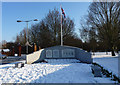
War Memorial
Built in 2011. The gates situated back left of the picture are the entrance to Memorial Park in Wickford.
Image: © terry joyce
Taken: 7 Feb 2012
0.23 miles
7
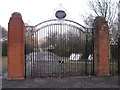
Wickford memorial park
The main entrance to Wickford memorial park
Image: © Fast Track images
Taken: 21 Jan 2010
0.24 miles