IMAGES TAKEN NEAR TO
The Oaks, WICKFORD, SS11 7GP
Introduction
This page details the photographs taken nearby to The Oaks, SS11 7GP by members of the Geograph project.
The Geograph project started in 2005 with the aim of publishing, organising and preserving representative images for every square kilometre of Great Britain, Ireland and the Isle of Man.

There are currently over 7.5m images from over14,400 individuals and you can help contribute to the project by visiting https://www.geograph.org.uk
Image Map (Loading...)


Getting Data...Please wait
Leaflet Map data © OpenStreetMap
Images are licensed for reuse under creativecommons.org/licenses/by-sa/2.0
Notes
- Clicking on the map will re-center to the selected point.
- The higher the marker number, the further away the image location is from the centre of the postcode.
Image Listing (7 Images Found)
Images are licensed for reuse under creativecommons.org/licenses/by-sa/2.0
Image
Details
Distance
1
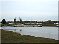
River Crouch launching ramp
On Hayes Farm Caravan Park
Image: © terry joyce
Taken: 29 Oct 2010
0.11 miles
2
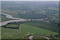
Hayes Farm Caravan Park
Quite a lot of this grid can be seen in the photo. The River Crouch and the power lines are the most obvious.
Image: © terry joyce
Taken: 14 Jun 2010
0.14 miles
3
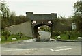
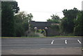
Railway Bridge over Hayes Chase
On the other side of the bridge lies a caravan site.
Image: © Robert Edwards
Taken: 9 Apr 2008
0.16 miles
4
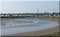
Meandering Crouch, Rawreth
Note the "leisure homes" on the other side of the river.
Image: © Roger Jones
Taken: 8 Apr 2017
0.17 miles
6

High and Dry
Boats on the other bank of the River Crouch.
Image: © terry joyce
Taken: 29 Oct 2010
0.19 miles
7
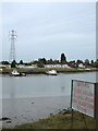
Don't touch
Overhead power lines crossing the River Crouch.
Hayes Farm Caravan Park on the other side.
Image: © terry joyce
Taken: 29 Oct 2010
0.24 miles