IMAGES TAKEN NEAR TO
Meadow Lane, WICKFORD, SS11 7DX
Introduction
This page details the photographs taken nearby to Meadow Lane, SS11 7DX by members of the Geograph project.
The Geograph project started in 2005 with the aim of publishing, organising and preserving representative images for every square kilometre of Great Britain, Ireland and the Isle of Man.

There are currently over 7.5m images from over14,400 individuals and you can help contribute to the project by visiting https://www.geograph.org.uk
Image Map (Loading...)


Getting Data...Please wait
Leaflet Map data © OpenStreetMap
Images are licensed for reuse under creativecommons.org/licenses/by-sa/2.0
Notes
- Clicking on the map will re-center to the selected point.
- The higher the marker number, the further away the image location is from the centre of the postcode.
Image Listing (5 Images Found)
Images are licensed for reuse under creativecommons.org/licenses/by-sa/2.0
Image
Details
Distance
1
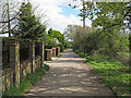
Public footpath on private track, Runwell
Footpath leading from South Hanningfield Way, Runwell to South Hanningfield.
Image: © Roger Jones
Taken: 25 Apr 2015
0.19 miles
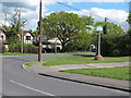
2
South Hanningfield Way
This leads to the footpath that goes to South Hanningfield.
Image: © terry joyce
Taken: 21 Feb 2012
0.20 miles
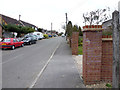
4
South Hanningfield Way
This road is part of the footpath to South Hanningfield.
Image: © terry joyce
Taken: 21 Feb 2012
0.23 miles
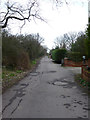
5
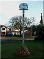
Runwell Village Sign
Located on a grass verge in Church End Lane.
Image: © terry joyce
Taken: 28 Dec 2009
0.24 miles