IMAGES TAKEN NEAR TO
Westbourne Grove, WESTCLIFF-ON-SEA, SS0 9TX
Introduction
This page details the photographs taken nearby to Westbourne Grove, SS0 9TX by members of the Geograph project.
The Geograph project started in 2005 with the aim of publishing, organising and preserving representative images for every square kilometre of Great Britain, Ireland and the Isle of Man.

There are currently over 7.5m images from over14,400 individuals and you can help contribute to the project by visiting https://www.geograph.org.uk
Image Map
Images are licensed for reuse under creativecommons.org/licenses/by-sa/2.0
Notes
- Clicking on the map will re-center to the selected point.
- The higher the marker number, the further away the image location is from the centre of the postcode.
Image Listing (4 Images Found)
Images are licensed for reuse under creativecommons.org/licenses/by-sa/2.0
Image
Details
Distance
3

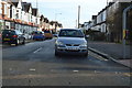
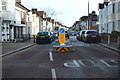
Westborough moon
Looking east along Westborough Road at night time.
Image: © keith baxter
Taken: 18 Mar 2003
0.21 miles
4
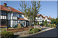
Clatterfield Gardens, Westcliff-on-Sea
Clatterfield Gardens dates from the mid-1930s when the area north of Fairfax Drive began to be developed.
Image: © David Kemp
Taken: 11 Sep 2016
0.25 miles