IMAGES TAKEN NEAR TO
Fairmead Avenue, WESTCLIFF-ON-SEA, SS0 9SA
Introduction
This page details the photographs taken nearby to Fairmead Avenue, SS0 9SA by members of the Geograph project.
The Geograph project started in 2005 with the aim of publishing, organising and preserving representative images for every square kilometre of Great Britain, Ireland and the Isle of Man.

There are currently over 7.5m images from over14,400 individuals and you can help contribute to the project by visiting https://www.geograph.org.uk
Image Map (Loading...)


Getting Data...Please wait
Leaflet Map data © OpenStreetMap
Images are licensed for reuse under creativecommons.org/licenses/by-sa/2.0
Notes
- Clicking on the map will re-center to the selected point.
- The higher the marker number, the further away the image location is from the centre of the postcode.
Image Listing (6 Images Found)
Images are licensed for reuse under creativecommons.org/licenses/by-sa/2.0
Image
Details
Distance
1

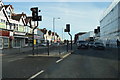
Westborough moon
Looking east along Westborough Road at night time.
Image: © keith baxter
Taken: 18 Mar 2003
0.07 miles
3
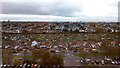
Westcliff-on-Sea from Southend University Hospital 20191101_150346
The view looking SSE from the Tower Block of Southend University Hospital. The houses and allotments visible are in Westcliff-on-Sea which is part of the Borough of Southend-on-Sea in Essex. The Thames Estuary is just visible.
Image: © Trevor Durritt
Taken: 1 Nov 2019
0.19 miles
5
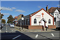
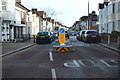
Westcliff Free Church
On the corner of Ronald Park Avenue and London Road, A13.
Image: © Robin Webster
Taken: 1 Oct 2018
0.21 miles