IMAGES TAKEN NEAR TO
West Road, WESTCLIFF-ON-SEA, SS0 9AU
Introduction
This page details the photographs taken nearby to West Road, SS0 9AU by members of the Geograph project.
The Geograph project started in 2005 with the aim of publishing, organising and preserving representative images for every square kilometre of Great Britain, Ireland and the Isle of Man.

There are currently over 7.5m images from over14,400 individuals and you can help contribute to the project by visiting https://www.geograph.org.uk
Image Map
Images are licensed for reuse under creativecommons.org/licenses/by-sa/2.0
Notes
- Clicking on the map will re-center to the selected point.
- The higher the marker number, the further away the image location is from the centre of the postcode.
Image Listing (11 Images Found)
Images are licensed for reuse under creativecommons.org/licenses/by-sa/2.0
Image
Details
Distance
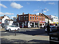
1
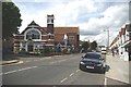
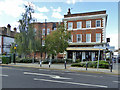
Trinity Methodist Church
Trinity Methodist Church Westcliff is on the corner of London Rd (A13) and Argyll Rd http://www.trinity-westcliff.org/news/index.php?option=com_content&view=article&id=61&Itemid=82
Image: © Glyn Baker
Taken: 13 Aug 2011
0.08 miles
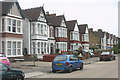
3
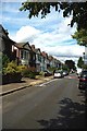
Brightwell Rd Westcliff
Just one of many streets of substantial (Edwardian?) Villas in this area.
Image: © Glyn Baker
Taken: 13 Aug 2011
0.11 miles
4
London Road, Westcliff on Sea
Leading out to the west of Southend the A13 is built up for many miles, lined with businesses of all kinds; this is the busy stretch through Westcliff on Sea.
Image: © Stephen McKay
Taken: 27 Aug 2011
0.11 miles
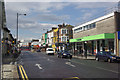
5
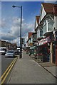
London Rd
A parade of shops in Westcliff
Image: © Glyn Baker
Taken: 13 Aug 2011
0.14 miles
6
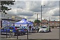
Community Policing Southend-on-Sea
I am not sure if this car park by Hamlet Court Rd counts as being in Prittlewell or Westcliff however today volunteers and community officers of the Essex (& Southend-on-Sea ) Constabulary were undertaking a crime prevention scheme issuing free UV security marker pens. From 1914 until 1969 the Borough of Southend-on-Sea had an independent police force.. I remember as a child seeing the Sergeants wearing white helmets. Five years after the merger with Essex Police the “and Southend-on-Sea" was dropped from the official title of the force. http://en.wikipedia.org/wiki/Southend-on-Sea_Borough_Police
Image: © Glyn Baker
Taken: 13 Aug 2011
0.17 miles
7
Ceylon Road, Westcliff-on-Sea
The part of Westcliff to the north of the C2C station comprises large semi-detached Victorian and Edwardian villas set in a grid of wide streets. Virtually all are now in multi-occupation.
Image: © David Kemp
Taken: 12 Aug 2015
0.17 miles
8
Cheap Appliances, London Road, Westcliff
They don't appear to mean the surgical sort.
Image: © Robin Webster
Taken: 1 Oct 2018
0.20 miles
9
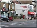
Westcliff-on-Sea: London Road 553 Post Office, and postbox № SS0 115
The name of the post office includes the street number to distinguish it from two other branches in London Road – at 1627 (closed a few years ago) and 1761 – both postally in Leigh-on-Sea rather than Westcliff as here.
This branch will close permanently on 23 September 2008; according to a notice inside, it will not affect the toy shop that it is within.
According to the Royal Mail's postbox list, the box is outside 555 London Road Post Office, which was indeed the case: the office opened in 1924 at 555 Londond Road (outside which the postbox still stands) and moved within the toy shop next door on 10 September 1986.
Image: © Chris Downer
Taken: 18 Sep 2008
0.22 miles
10
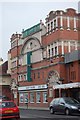
The Trading Room, Westcliff
Pub, formerly a bank.
Image: © Robin Webster
Taken: 1 Oct 2018
0.24 miles