IMAGES TAKEN NEAR TO
Meadway, WESTCLIFF-ON-SEA, SS0 8PJ
Introduction
This page details the photographs taken nearby to Meadway, SS0 8PJ by members of the Geograph project.
The Geograph project started in 2005 with the aim of publishing, organising and preserving representative images for every square kilometre of Great Britain, Ireland and the Isle of Man.

There are currently over 7.5m images from over14,400 individuals and you can help contribute to the project by visiting https://www.geograph.org.uk
Image Map (Loading...)


Getting Data...Please wait
Leaflet Map data © OpenStreetMap
Images are licensed for reuse under creativecommons.org/licenses/by-sa/2.0
Notes
- Clicking on the map will re-center to the selected point.
- The higher the marker number, the further away the image location is from the centre of the postcode.
Image Listing (33 Images Found)
Images are licensed for reuse under creativecommons.org/licenses/by-sa/2.0
Image
Details
Distance
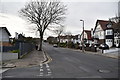
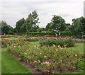
4
Chalkwell Park
The house is in Kings Road. Fuel storage tanks can just be made out on the Kent side of the Thames estuary.
Image: © David Kemp
Taken: 3 Aug 2010
0.11 miles

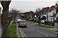
7

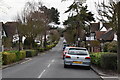
The Drive, Leasway, Ridgeway Gardens junction
Image: © N Chadwick
Taken: 2 Mar 2019
0.13 miles
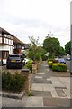
8
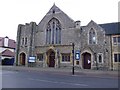
Westcliff United Reformed Church
Kings Road, Chalkwell
Image: © Julieanne Savage
Taken: 3 Feb 2007
0.15 miles
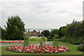
10
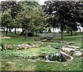
The Ponds, Chalkwell Park
Series of pools forming a wildlife area.
Image: © John Myers
Taken: 3 Sep 2006
0.15 miles