IMAGES TAKEN NEAR TO
Imperial Avenue, WESTCLIFF-ON-SEA, SS0 8NE
Introduction
This page details the photographs taken nearby to Imperial Avenue, SS0 8NE by members of the Geograph project.
The Geograph project started in 2005 with the aim of publishing, organising and preserving representative images for every square kilometre of Great Britain, Ireland and the Isle of Man.

There are currently over 7.5m images from over14,400 individuals and you can help contribute to the project by visiting https://www.geograph.org.uk
Image Map (Loading...)


Getting Data...Please wait
Leaflet Map data © OpenStreetMap
Images are licensed for reuse under creativecommons.org/licenses/by-sa/2.0
Notes
- Clicking on the map will re-center to the selected point.
- The higher the marker number, the further away the image location is from the centre of the postcode.
Image Listing (24 Images Found)
Images are licensed for reuse under creativecommons.org/licenses/by-sa/2.0
Image
Details
Distance
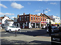
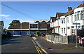
2
The Trading Room, Southend
522, London Road, Southend.
Image: © Phillip Perry
Taken: 4 Aug 2008
0.09 miles
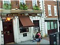
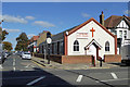
3
The Trading Room, Westcliff
Pub, formerly a bank.
Image: © Robin Webster
Taken: 1 Oct 2018
0.11 miles
4
Cheap Appliances, London Road, Westcliff
They don't appear to mean the surgical sort.
Image: © Robin Webster
Taken: 1 Oct 2018
0.13 miles
5
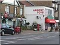
Westcliff-on-Sea: London Road 553 Post Office, and postbox № SS0 115
The name of the post office includes the street number to distinguish it from two other branches in London Road – at 1627 (closed a few years ago) and 1761 – both postally in Leigh-on-Sea rather than Westcliff as here.
This branch will close permanently on 23 September 2008; according to a notice inside, it will not affect the toy shop that it is within.
According to the Royal Mail's postbox list, the box is outside 555 London Road Post Office, which was indeed the case: the office opened in 1924 at 555 Londond Road (outside which the postbox still stands) and moved within the toy shop next door on 10 September 1986.
Image: © Chris Downer
Taken: 18 Sep 2008
0.14 miles
6
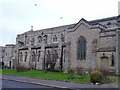
Saint Saviours
Kings Road, Westcliff on Sea
http://www.btinternet.com/~ianrose82/westcliffss.htm
Image: © Julieanne Savage
Taken: 3 Feb 2007
0.15 miles
7
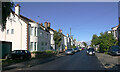
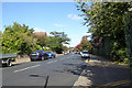
Cotswold Road, Westcliff
Taken from the junction with Finchley Road.
Image: © David Kemp
Taken: 5 Oct 2021
0.16 miles
9
Southend and Westcliff Hebrew Congregation synagogue, Finchley Road, Westcliff
The synagogue was built in 1968 and has been in use since then.
Image: © David Kemp
Taken: 5 Oct 2021
0.17 miles
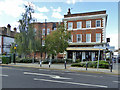
10
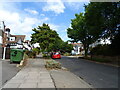
Westcliff Free Church
On the corner of Ronald Park Avenue and London Road, A13.
Image: © Robin Webster
Taken: 1 Oct 2018
0.17 miles