IMAGES TAKEN NEAR TO
Seaforth Road, WESTCLIFF-ON-SEA, SS0 7SN
Introduction
This page details the photographs taken nearby to Seaforth Road, SS0 7SN by members of the Geograph project.
The Geograph project started in 2005 with the aim of publishing, organising and preserving representative images for every square kilometre of Great Britain, Ireland and the Isle of Man.

There are currently over 7.5m images from over14,400 individuals and you can help contribute to the project by visiting https://www.geograph.org.uk
Image Map
Images are licensed for reuse under creativecommons.org/licenses/by-sa/2.0
Notes
- Clicking on the map will re-center to the selected point.
- The higher the marker number, the further away the image location is from the centre of the postcode.
Image Listing (50 Images Found)
Images are licensed for reuse under creativecommons.org/licenses/by-sa/2.0
Image
Details
Distance
1

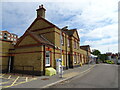
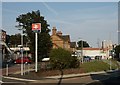
Westcliff Station
From Station Road, looking west to the station approach.
Image: © Trevor Harris
Taken: 23 Jul 2011
0.06 miles
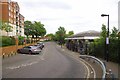
2
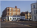
Station Road at the junction of Holland Road, Westcliff
Image: © David Howard
Taken: 24 May 2012
0.06 miles
3
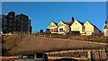
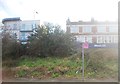
Is that graffiti in the newly prepared flower bed?
Image: © Chris Morgan
Taken: 28 Dec 2016
0.07 miles
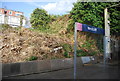
5
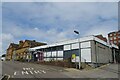
Westcliff Railway Station
Westcliff railway Station, looking east along Station Road
Image: © Paul Collins
Taken: 1 Aug 2007
0.07 miles
7
Westcliff Station Approach
Less than an hour from London C2C permitting!
Image: © Glyn Baker
Taken: 20 May 2016
0.07 miles
9
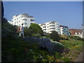
Art deco flats on Clifton Drive from Western Esplanade
Image: © David Howard
Taken: 24 May 2012
0.08 miles