IMAGES TAKEN NEAR TO
Argyll Road, WESTCLIFF-ON-SEA, SS0 7HL
Introduction
This page details the photographs taken nearby to Argyll Road, SS0 7HL by members of the Geograph project.
The Geograph project started in 2005 with the aim of publishing, organising and preserving representative images for every square kilometre of Great Britain, Ireland and the Isle of Man.

There are currently over 7.5m images from over14,400 individuals and you can help contribute to the project by visiting https://www.geograph.org.uk
Image Map (Loading...)


Getting Data...Please wait
Leaflet Map data © OpenStreetMap
Images are licensed for reuse under creativecommons.org/licenses/by-sa/2.0
Notes
- Clicking on the map will re-center to the selected point.
- The higher the marker number, the further away the image location is from the centre of the postcode.
Image Listing (20 Images Found)
Images are licensed for reuse under creativecommons.org/licenses/by-sa/2.0
Image
Details
Distance
1
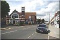
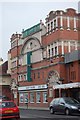
Trinity Methodist Church
Trinity Methodist Church Westcliff is on the corner of London Rd (A13) and Argyll Rd http://www.trinity-westcliff.org/news/index.php?option=com_content&view=article&id=61&Itemid=82
Image: © Glyn Baker
Taken: 13 Aug 2011
0.06 miles
2
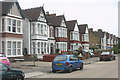
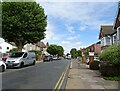
Ceylon Road, Westcliff-on-Sea
The part of Westcliff to the north of the C2C station comprises large semi-detached Victorian and Edwardian villas set in a grid of wide streets. Virtually all are now in multi-occupation.
Image: © David Kemp
Taken: 12 Aug 2015
0.07 miles
3
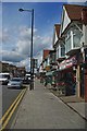
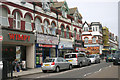
London Rd
A parade of shops in Westcliff
Image: © Glyn Baker
Taken: 13 Aug 2011
0.09 miles
4
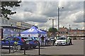
Community Policing Southend-on-Sea
I am not sure if this car park by Hamlet Court Rd counts as being in Prittlewell or Westcliff however today volunteers and community officers of the Essex (& Southend-on-Sea ) Constabulary were undertaking a crime prevention scheme issuing free UV security marker pens. From 1914 until 1969 the Borough of Southend-on-Sea had an independent police force.. I remember as a child seeing the Sergeants wearing white helmets. Five years after the merger with Essex Police the “and Southend-on-Sea" was dropped from the official title of the force. http://en.wikipedia.org/wiki/Southend-on-Sea_Borough_Police
Image: © Glyn Baker
Taken: 13 Aug 2011
0.12 miles
6
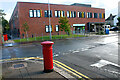
Valkyrie Road Primary Care Centre, Westcliff
Taken from the corner of Finchley Road.
Image: © David Kemp
Taken: 5 Oct 2021
0.14 miles
7
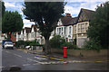
Finchley Road, Westcliff on Sea
A terrace of substantial, probably Edwardian, houses line the north side of Finchley Road; the nearest one has clearly seen better days.
Image: © Stephen McKay
Taken: 27 Aug 2011
0.14 miles
8
Hamlet Court Road, Westcliff-on-Sea
Hamlet Court Road was known in the earlier part of the C20 as The Bond Street of the East Coast so up-market were its shops and restaurants.
Image: © David Kemp
Taken: 12 Aug 2015
0.15 miles
10
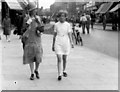
Hamlet Court Road, Westcliff-on-Sea in 1929
Photograph taken walking down Hamlet Court Road in Westcliff-on-Sea on 28th August, 1929. The buildings on the right side of the road are still standing and recognisable; the street is still largely a shopping area. (This image features Dorothy Mann (on right), the contributor's mother, and Kate Howard Manning (nee Feasey) on left, the photographer's wife. The image is taken from a family collection passed down to Clinton Mann by his mother Dorothy).
Image: © William Beckwith Manning
Taken: 28 Aug 1929
0.15 miles