IMAGES TAKEN NEAR TO
Mendip Crescent, WESTCLIFF-ON-SEA, SS0 0HN
Introduction
This page details the photographs taken nearby to Mendip Crescent, SS0 0HN by members of the Geograph project.
The Geograph project started in 2005 with the aim of publishing, organising and preserving representative images for every square kilometre of Great Britain, Ireland and the Isle of Man.

There are currently over 7.5m images from over14,400 individuals and you can help contribute to the project by visiting https://www.geograph.org.uk
Image Map
Images are licensed for reuse under creativecommons.org/licenses/by-sa/2.0
Notes
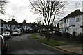
- Clicking on the map will re-center to the selected point.
- The higher the marker number, the further away the image location is from the centre of the postcode.
Image Listing (10 Images Found)
Images are licensed for reuse under creativecommons.org/licenses/by-sa/2.0
Image
Details
Distance
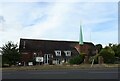
3
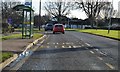
St Cedds Westcliff-on-Sea
St Cedds is a modern building in Bridgewater Drive.
Image: © Glyn Baker
Taken: 10 Feb 2006
0.13 miles
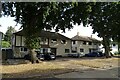
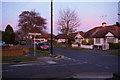
4
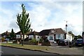
Bungalows on Bridgwater Drive, Southend-on-Sea
Image: © JThomas
Taken: 25 Aug 2022
0.14 miles
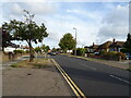
5
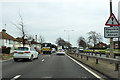
A127 towards Southend
Possible queues ahead. Nothing special yet, the really chronic queues are a good way on.
Image: © Robin Webster
Taken: 6 Apr 2018
0.17 miles
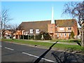
9
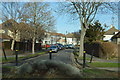
Corner of Glastonbury Chase and Exford Avenue, Westcliff-on-Sea
The various streets in this area of Westcliff are named after places in the West Country.
Image: © Christopher Hilton
Taken: 8 Dec 2013
0.23 miles