IMAGES TAKEN NEAR TO
Kenilworth Gardens, WESTCLIFF-ON-SEA, SS0 0BA
Introduction
This page details the photographs taken nearby to Kenilworth Gardens, SS0 0BA by members of the Geograph project.
The Geograph project started in 2005 with the aim of publishing, organising and preserving representative images for every square kilometre of Great Britain, Ireland and the Isle of Man.

There are currently over 7.5m images from over14,400 individuals and you can help contribute to the project by visiting https://www.geograph.org.uk
Image Map
Images are licensed for reuse under creativecommons.org/licenses/by-sa/2.0
Notes
- Clicking on the map will re-center to the selected point.
- The higher the marker number, the further away the image location is from the centre of the postcode.
Image Listing (7 Images Found)
Images are licensed for reuse under creativecommons.org/licenses/by-sa/2.0
Image
Details
Distance
1
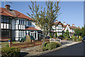
Kenilworth Gardens
An attractive stretch of suburban dual-carriageway.
Image: © Trevor Harris
Taken: 2 Oct 2009
0.11 miles
2
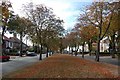
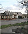
Clatterfield Gardens, Westcliff-on-Sea
Clatterfield Gardens dates from the mid-1930s when the area north of Fairfax Drive began to be developed.
Image: © David Kemp
Taken: 11 Sep 2016
0.16 miles
3
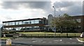
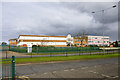
St. Thomas More High School
St Thomas More High School. Catholic High School, Kenilworth Gardens, Leigh-on-Sea.
Image: © Paul Collins
Taken: 20 Jul 2007
0.17 miles
4
St. Thomas More High School
A Roman Catholic school, as one might guess.
Image: © Robin Webster
Taken: 28 Feb 2016
0.18 miles
5
Westcliff High School for Boys
One of three senior schools within a few hundred metres of each other in this square.
Image: © John Myers
Taken: 8 Apr 2008
0.22 miles
6
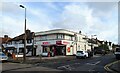
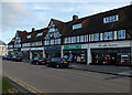
Convenience store on Bridgwater Drive, Southend-on-Sea
Image: © JThomas
Taken: 25 Aug 2022
0.22 miles