
IMAGES TAKEN NEAR TO
Wellstead Gardens, WESTCLIFF-ON-SEA, SS0 0AY
Introduction
This page details the photographs taken nearby to Wellstead Gardens, SS0 0AY by members of the Geograph project.
The Geograph project started in 2005 with the aim of publishing, organising and preserving representative images for every square kilometre of Great Britain, Ireland and the Isle of Man.

There are currently over 7.5m images from over14,400 individuals and you can help contribute to the project by visiting https://www.geograph.org.uk
Image Map
Images are licensed for reuse under creativecommons.org/licenses/by-sa/2.0
Notes
- Clicking on the map will re-center to the selected point.
- The higher the marker number, the further away the image location is from the centre of the postcode.
Image Listing (8 Images Found)
Images are licensed for reuse under creativecommons.org/licenses/by-sa/2.0
Image
Details
Distance
1
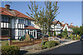
Clatterfield Gardens, Westcliff-on-Sea
Clatterfield Gardens dates from the mid-1930s when the area north of Fairfax Drive began to be developed.
Image: © David Kemp
Taken: 11 Sep 2016
0.10 miles
2
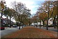
Kenilworth Gardens
An attractive stretch of suburban dual-carriageway.
Image: © Trevor Harris
Taken: 2 Oct 2009
0.19 miles
4
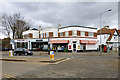
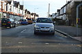
Eastwood Boulevard Post Office
The block, apparently called The Corner House, also has a hairdressers and picture framers. The last has an extraordinary trading name: 'The Pouch of Douglas'. This is an internal feature of female anatomy between the rectum and the uterus - why that name?
Image: © Robin Webster
Taken: 28 Feb 2016
0.21 miles
6
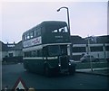
Preserved Bus at Eastwood Boulevard
Taken in April 1973, this photo shows 55 (EHO 228) a 1942 Guy Arab II with Reading 56-seater bodywork built in 1955 in Eastwood Boulevard on a tour of Southend-on-Sea's former trolleybus system. This location was worked by routes 28A/B which went via London Road, Nelson Road and Fairfax Drive until the closure of the trolleybus system on the 28th October 1954. This vehicle was owned by Provincial (Gosport & Fareham Omnibus Co.Ltd) but is now preserved. The buildings behind the vehicle have since been demolished.
Image: © David Hillas
Taken: 15 Apr 1973
0.23 miles
7
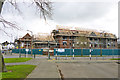
Building site, corner of Manchester Drive and Eastwood Boulevard
Redevelopment of a commercial site that once was a large laundry.
Image: © Robin Webster
Taken: 28 Feb 2016
0.24 miles
8
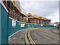
Building site, Nelson Road
Redevelopment of a commercial site that once was a large laundry.
Image: © Robin Webster
Taken: 28 Feb 2016
0.24 miles