IMAGES TAKEN NEAR TO
Southbourne Grove, WESTCLIFF-ON-SEA, SS0 0AF
Introduction
This page details the photographs taken nearby to Southbourne Grove, SS0 0AF by members of the Geograph project.
The Geograph project started in 2005 with the aim of publishing, organising and preserving representative images for every square kilometre of Great Britain, Ireland and the Isle of Man.

There are currently over 7.5m images from over14,400 individuals and you can help contribute to the project by visiting https://www.geograph.org.uk
Image Map (Loading...)


Getting Data...Please wait
Leaflet Map data © OpenStreetMap
Images are licensed for reuse under creativecommons.org/licenses/by-sa/2.0
Notes
- Clicking on the map will re-center to the selected point.
- The higher the marker number, the further away the image location is from the centre of the postcode.
Image Listing (7 Images Found)
Images are licensed for reuse under creativecommons.org/licenses/by-sa/2.0
Image
Details
Distance
3
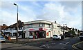
Convenience store on Bridgwater Drive, Southend-on-Sea
Image: © JThomas
Taken: 25 Aug 2022
0.18 miles
5
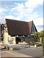
St. Peter's Church, Westcliff-on-Sea
St. Peter's Church, Eastbourne Grove, Westcliff-on-Sea.
Image: © Paul Collins
Taken: 6 Aug 2007
0.24 miles
6
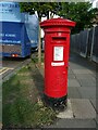
George VI postbox on Carlton Avenue, Southend-on-Sea
Postbox No. SS0 80. See Image for context.
Image: © JThomas
Taken: 25 Aug 2022
0.24 miles
7
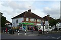
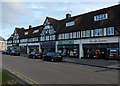
Post Office and shop on Carlton Avenue, Southend-on-Sea
Showing position of Postbox No. SS0 80.
See Image] for postbox.
Image: © JThomas
Taken: 25 Aug 2022
0.24 miles