IMAGES TAKEN NEAR TO
Malt Crescent, PETERLEE, SR8 4NT
Introduction
This page details the photographs taken nearby to Malt Crescent, SR8 4NT by members of the Geograph project.
The Geograph project started in 2005 with the aim of publishing, organising and preserving representative images for every square kilometre of Great Britain, Ireland and the Isle of Man.

There are currently over 7.5m images from over14,400 individuals and you can help contribute to the project by visiting https://www.geograph.org.uk
Image Map
Images are licensed for reuse under creativecommons.org/licenses/by-sa/2.0
Notes
- Clicking on the map will re-center to the selected point.
- The higher the marker number, the further away the image location is from the centre of the postcode.
Image Listing (13 Images Found)
Images are licensed for reuse under creativecommons.org/licenses/by-sa/2.0
Image
Details
Distance
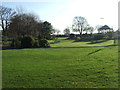
5
Welfare Park, Show Dahlia Artwork, Horden
Image: © Alex McGregor
Taken: 6 Oct 2010
0.13 miles
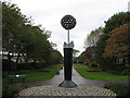
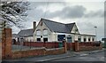
7
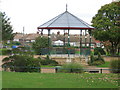
Welfare Park
Horden Colliery Welfare Park
Image: © george hurrell
Taken: 26 Nov 2006
0.19 miles
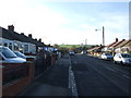
8
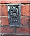
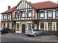
Horden, South Terrace
The OS Flush Bracket G4888 is embedded into the roadside wall on the north side of the road. This is the boundary wall to Horden Catholic Social Club.
Image: © Mel Towler
Taken: 30 Dec 2022
0.20 miles
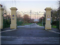
9
Horden, South Terrace
The OS Flush Bracket G4888 is embedded into the roadside wall on the north side of the road. This is the boundary wall to Horden Catholic Social Club.
Image: © Mel Towler
Taken: 30 Dec 2022
0.20 miles