IMAGES TAKEN NEAR TO
Jedburgh Close, SEAHAM, SR7 9SB
Introduction
This page details the photographs taken nearby to Jedburgh Close, SR7 9SB by members of the Geograph project.
The Geograph project started in 2005 with the aim of publishing, organising and preserving representative images for every square kilometre of Great Britain, Ireland and the Isle of Man.

There are currently over 7.5m images from over14,400 individuals and you can help contribute to the project by visiting https://www.geograph.org.uk
Image Map
Images are licensed for reuse under creativecommons.org/licenses/by-sa/2.0
Notes
- Clicking on the map will re-center to the selected point.
- The higher the marker number, the further away the image location is from the centre of the postcode.
Image Listing (21 Images Found)
Images are licensed for reuse under creativecommons.org/licenses/by-sa/2.0
Image
Details
Distance
3
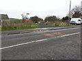
Hawthorn/Ryhope Way or Cycle Route 1 crossing point on the B1285
Image: © Clive Nicholson
Taken: 31 Jan 2014
0.11 miles
4
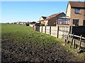
Field adjoining the Winds Lonnen Estate, Murton
Image: © Oliver Dixon
Taken: 16 Jan 2007
0.11 miles
5
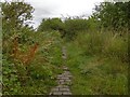
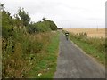
Old road, Murton
Probably an access route to Murton Station which was a junction on the Durham and Sunderland Railway.
Image: © Richard Webb
Taken: 9 Aug 2016
0.11 miles
6

Cycle Route 1 heading South from Murton
Image: © Clive Nicholson
Taken: 31 Jan 2014
0.12 miles