IMAGES TAKEN NEAR TO
Matthews Road, SEAHAM, SR7 9DF
Introduction
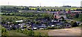
This page details the photographs taken nearby to Matthews Road, SR7 9DF by members of the Geograph project.
The Geograph project started in 2005 with the aim of publishing, organising and preserving representative images for every square kilometre of Great Britain, Ireland and the Isle of Man.

There are currently over 7.5m images from over14,400 individuals and you can help contribute to the project by visiting https://www.geograph.org.uk
Image Map
Images are licensed for reuse under creativecommons.org/licenses/by-sa/2.0
Notes
- Clicking on the map will re-center to the selected point.
- The higher the marker number, the further away the image location is from the centre of the postcode.
Image Listing (3 Images Found)
Images are licensed for reuse under creativecommons.org/licenses/by-sa/2.0
Image
Details
Distance
2
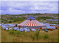
American Circus, Murton
Set up on the waste ground to the south of Dalton Retail Park (on the right of frame). The town of Murton behind the big top.
Image: © wfmillar
Taken: 14 Sep 2009
0.22 miles