IMAGES TAKEN NEAR TO
Burnside Cottages, SEAHAM, SR7 8QU
Introduction
This page details the photographs taken nearby to Burnside Cottages, SR7 8QU by members of the Geograph project.
The Geograph project started in 2005 with the aim of publishing, organising and preserving representative images for every square kilometre of Great Britain, Ireland and the Isle of Man.

There are currently over 7.5m images from over14,400 individuals and you can help contribute to the project by visiting https://www.geograph.org.uk
Image Map
Images are licensed for reuse under creativecommons.org/licenses/by-sa/2.0
Notes
- Clicking on the map will re-center to the selected point.
- The higher the marker number, the further away the image location is from the centre of the postcode.
Image Listing (10 Images Found)
Images are licensed for reuse under creativecommons.org/licenses/by-sa/2.0
Image
Details
Distance
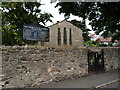
3
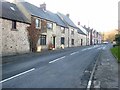
St Andrew's Churchyard, Dalton-Le-Dale
The houses are on St Cuthberts Terrace Image
Image: © Andrew Curtis
Taken: 12 Feb 2010
0.12 miles
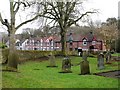
5
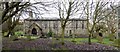
St Andrew's Church Dalton-Le-Dale
The first part of the village name, Dalton, comes from the Old English for 'farmstead in a valley'. 'Le Dale' was added in the medieval period to distinguish it from Dalton Piercy Image
http://www.keystothepast.info/article/10339/Site-Details?PRN=D6777
The church has mainly C13 features with extensive restoration by C. Hodgson Fowler in 1907 http://www.keystothepast.info/article/10339/Site-Details?PRN=D12579
Image: © Andrew Curtis
Taken: 12 Feb 2010
0.14 miles
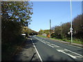
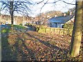
8
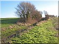
Old stagecoach road, Dalton-le-Dale
It is believed that this lane between Dalton-le-Dale and Cold Hesledon was at one time the stagecoach road along the County Durham coast.
Image: © Oliver Dixon
Taken: 16 Jan 2007
0.22 miles
9
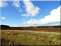
Looking northwest from the old railway
This old railway path runs south from Dawdon. On the right across the fields can be seen houses at Dalton le Dale, and on the horizon, the west side of Seaham.
Image: © Robert Graham
Taken: 9 Oct 2013
0.23 miles