IMAGES TAKEN NEAR TO
Princess Road, SEAHAM, SR7 7SP
Introduction
This page details the photographs taken nearby to Princess Road, SR7 7SP by members of the Geograph project.
The Geograph project started in 2005 with the aim of publishing, organising and preserving representative images for every square kilometre of Great Britain, Ireland and the Isle of Man.

There are currently over 7.5m images from over14,400 individuals and you can help contribute to the project by visiting https://www.geograph.org.uk
Image Map
Images are licensed for reuse under creativecommons.org/licenses/by-sa/2.0
Notes
- Clicking on the map will re-center to the selected point.
- The higher the marker number, the further away the image location is from the centre of the postcode.
Image Listing (24 Images Found)
Images are licensed for reuse under creativecommons.org/licenses/by-sa/2.0
Image
Details
Distance
2
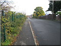
Seaham Harbour railway station (site), County Durham
Opened in 1855 as Seaham by the Londonderry Seaham & Sunderland Railway, this station was renamed Seaham Harbour in 1925 but closed in 1939 and was later demolished.
View north west across the former forecourt towards the single platform. The area has been mostly redeveloped. The wooden fence appears to follow the alignment of the back of the platform, so the platform was to the left of it. The two trees on the right appear to be where the single storey station building was, with the station hotel just beyond it. Some old bricks at the base of the fence may be the only evidence of the site's previous use.
Image: © Nigel Thompson
Taken: 18 Jan 2017
0.12 miles
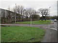
3
Roundabout on New Strangford Road, Seaham
On the 1404. The green belt in the photo lies along Dawdon Dene, a deep valley which separates New Seaham from Seaham Harbour.
Image: © Oliver Dixon
Taken: 16 Jan 2007
0.13 miles
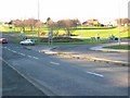
5

Dawdon Burn
Flowing through Dawdon dene Park.
Image: © Mick Garratt
Taken: 7 Jul 2016
0.18 miles
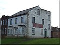
6
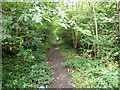
Dismantled railway line, Seaham
The railway was originally built to connect Seaham Colliery, situated to the west of the town, with the Harbour for the east coast coal trade.
Image: © Andrew Curtis
Taken: 9 Oct 2009
0.19 miles
7

Parish Church of St John the Evangelist
Parish church. 1835-40 by Thomas Prosser, north aisle added 1860, choir and vicar's vestries added by R.J. Johnson in 1885-6. Dressed limestone with sandstone dressings and moderate-pitched graduated Welsh slate roofs. West tower, aisleless nave and chancel, north aisle, north choir and vicar's vestries. Perpendicular style. Windows have mainly rectilinear tracery with trefoil-headed lights, chamfered reveals, hoodmoulds and alternating jambs.
See description here: https://keystothepast.info/search-records/results-of-search/results-of-search-2/site-details/?PRN=D36106 https://web.archive.org/web/20221119095506/https://keystothepast.info/search-records/results-of-search/results-of-search-2/site-details/?PRN=D36106
Image: © Andrew Curtis
Taken: 9 Oct 2009
0.20 miles
8
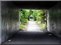
On the route of the Seaham railway incline
The incline carried coal wagons down to Seaham Harbour. It was 'self-acting' in that wagons laden with coal would run down the incline, pulling empty ones to the top by means of ropes and pulleys. Very sad to see it as it is now, just an overgrown footpath.
Image: © John Lucas
Taken: 13 Aug 2012
0.20 miles
9
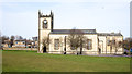
Church of St John the Evangelist
The church as seen from the south over a grassed field which once was the graveyard but the monuments have been removed due to instability and are arranged around and against the perimeter wall.
Image: © Trevor Littlewood
Taken: 14 Feb 2019
0.20 miles
10

Parish Church of St.John's, New Seaham
Built in 1857 due to the rapid expansion of New Seaham and the inability of the old Church of St.Mary's to be able to cope with all the extra burials.
To give some idea of this, the parish census for Seaham in 1841 was 153, by 1851 it was at 729, by 1861 it was an incredible 2591, and by 1891 it was close to 4800 souls.
Image: © Matthew Hatton
Taken: 16 Jan 2016
0.20 miles