IMAGES TAKEN NEAR TO
Aged Miners Homes, Hill Crescent, SEAHAM, SR7 7PE
Introduction
This page details the photographs taken nearby to Aged Miners Homes, Hill Crescent, SR7 7PE by members of the Geograph project.
The Geograph project started in 2005 with the aim of publishing, organising and preserving representative images for every square kilometre of Great Britain, Ireland and the Isle of Man.

There are currently over 7.5m images from over14,400 individuals and you can help contribute to the project by visiting https://www.geograph.org.uk
Image Map
Images are licensed for reuse under creativecommons.org/licenses/by-sa/2.0
Notes
- Clicking on the map will re-center to the selected point.
- The higher the marker number, the further away the image location is from the centre of the postcode.
Image Listing (14 Images Found)
Images are licensed for reuse under creativecommons.org/licenses/by-sa/2.0
Image
Details
Distance
1
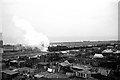
The old industrial North East, Seaham ? 1966
This view captures two of the classic features of the mining area of north east England. A former North Eastern Railway (BR Class Q6) hauls a load of coal hoppers from Seaham Colliery up to the main line, from which the view is taken. In the foreground is an area of allotment 'gardens', characterised more by the abundance of pigeon lofts than the growing of vegetables, although the occasional greenhouse is visible.
Remarkably, the railway line has survived the death of the mining industry, and serves a waste recycling centre. The allotments too survive, with the likelihood that some of the lofts are the ones visible in this view.
Image: © Alan Murray-Rust
Taken: 26 Mar 1966
0.12 miles
3
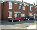
Longnewton Street, Dawdon, Seaham
View of ex-colliery houses immediately following renovations paid for by EU project.
Image: © Irene Marlborough
Taken: 24 Jun 2002
0.19 miles
4
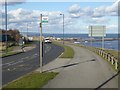
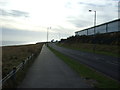
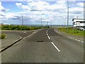
Port access road at Seaham Harbour
The A182 links the A19 to Seaham Harbour. The footway carries both the Durham Coast Path and the England Coast Path.
Image: © Oliver Dixon
Taken: 10 Feb 2016
0.21 miles
5
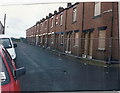
Longnewton Street before demolition
The houses shown were demolished in 2002. They had been colliery houses divided into flats.
Image: © Irene Marlborough
Taken: Unknown
0.21 miles
6
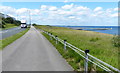
England Coast Path at Seaham
Running north alongside the A182.
Image: © Mat Fascione
Taken: 24 Jun 2017
0.21 miles
8
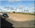
Waste Ground Where School Street Stood
This photo taken on Longnewton Street shows where houses on School Street and Longnewton Street had been demolished. Parkside is in the distance.
Image: © Irene Marlborough
Taken: 24 Jun 2002
0.22 miles