IMAGES TAKEN NEAR TO
Theresa Street, SEAHAM, SR7 7NE
Introduction
This page details the photographs taken nearby to Theresa Street, SR7 7NE by members of the Geograph project.
The Geograph project started in 2005 with the aim of publishing, organising and preserving representative images for every square kilometre of Great Britain, Ireland and the Isle of Man.

There are currently over 7.5m images from over14,400 individuals and you can help contribute to the project by visiting https://www.geograph.org.uk
Image Map
Images are licensed for reuse under creativecommons.org/licenses/by-sa/2.0
Notes
- Clicking on the map will re-center to the selected point.
- The higher the marker number, the further away the image location is from the centre of the postcode.
Image Listing (12 Images Found)
Images are licensed for reuse under creativecommons.org/licenses/by-sa/2.0
Image
Details
Distance
1
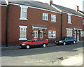
Longnewton Street, Dawdon, Seaham
View of ex-colliery houses immediately following renovations paid for by EU project.
Image: © Irene Marlborough
Taken: 24 Jun 2002
0.13 miles
2
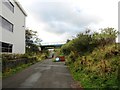
Path under the railway
This path leads up to Dawdon park and playing fields.
Image: © Robert Graham
Taken: 9 Oct 2013
0.13 miles
3
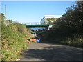
Railway bridge over Edith Street in Dawdon
For the East Coast Line
Image: © Peter Robinson
Taken: 7 Oct 2012
0.15 miles
4
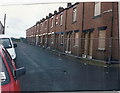
Longnewton Street before demolition
The houses shown were demolished in 2002. They had been colliery houses divided into flats.
Image: © Irene Marlborough
Taken: Unknown
0.16 miles
6
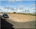
Waste Ground Where School Street Stood
This photo taken on Longnewton Street shows where houses on School Street and Longnewton Street had been demolished. Parkside is in the distance.
Image: © Irene Marlborough
Taken: 24 Jun 2002
0.18 miles
7
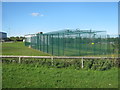
Practice nets at Dawdon Welfare Cricket Club
Image: © Peter Robinson
Taken: 7 Oct 2012
0.21 miles
10
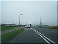
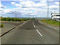
A182 East Cliff Road nears Dawdon roundabout
Image: © Colin Pyle
Taken: 3 Nov 2015
0.22 miles