IMAGES TAKEN NEAR TO
Tyne Street, SEAHAM, SR7 7EW
Introduction
This page details the photographs taken nearby to Tyne Street, SR7 7EW by members of the Geograph project.
The Geograph project started in 2005 with the aim of publishing, organising and preserving representative images for every square kilometre of Great Britain, Ireland and the Isle of Man.

There are currently over 7.5m images from over14,400 individuals and you can help contribute to the project by visiting https://www.geograph.org.uk
Image Map
Images are licensed for reuse under creativecommons.org/licenses/by-sa/2.0
Notes
- Clicking on the map will re-center to the selected point.
- The higher the marker number, the further away the image location is from the centre of the postcode.
Image Listing (107 Images Found)
Images are licensed for reuse under creativecommons.org/licenses/by-sa/2.0
Image
Details
Distance
1
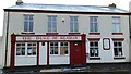
The Duke of Seaham
The internals of this public house seem to have been gutted and the building is beginning to look a little forlorn. It is my understanding that this was previously known as the Duke of Wellington. It was so named after the Duke of Wellington himself visited the Londonderry's at there family seat in Seaham Hall around 1827. It is on South Railway Street.
Image: © Matthew Hatton
Taken: 16 Jan 2016
0.04 miles
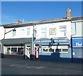
3
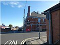
The Inn Between
On the corner of South Railway Street and Adelaide Row. Originally a Newcastle Breweries pub and previously named the Masons Arms (1831-1861) and Northumberland Arms. It acquired the name The Inn Between in the 1980s. It was refurbished and opened up in 2020 after being closed and boarded up for ten years.
Image
Image: © Gerald England
Taken: 18 Oct 2022
0.05 miles
4
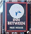
Sign of the Inn Between
Sign for the Inn Between Image
Image: © Gerald England
Taken: 18 Oct 2022
0.05 miles
5
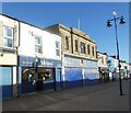
Valentes Seaham
The cafe on Church Street was established in 1920 and was originally an ice cream parlour. Woolworths opened next door in 1936. It closed in 1989 and for a time was an Ethel Austin shop. More recently it has housed a charity shop.
Image: © Gerald England
Taken: 18 Oct 2022
0.05 miles
6
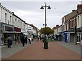
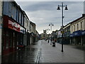
Church Street, Seaham
A pedestrianised shopping street. As an extensive part of the town nearby has become a large modern shopping mall and supermarket complex the traditional outlets here look like they are struggling to survive. The fake seagulls on the top of the lamp-posts and brightly coloured bicycle motifs make interesting features.
Image: © Andrew Curtis
Taken: 9 Oct 2009
0.05 miles
7
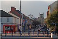
Church Street
Leading up to St John's Church.
Image: © Mick Garratt
Taken: 7 Nov 2013
0.05 miles
8
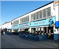
The Hat and Feathers
Originally three shops, numbers 57 to 59 Church Street were a pawnbrokers, wardrobe dealer, and chemist and dentist during the 1890s. Following the turn of the century they went on to become a milliners – hat makers – confectioners and drapers. Then for almost 60 years, from 1923 to 1981, two of the shops were home to Doggarts family run department store, which sold furniture, clothes and fine hats with feathers. In 2013 after a £1.2m conversion the premises became a Wetherspoon pub. https://cannybrew.com/media/photo-galleries/weatherspoons-turn-former-seaham-seaside-department-store-into-latest-pub-gallery/
Image
Image: © Gerald England
Taken: 18 Oct 2022
0.06 miles
9
Memory Lane and Oddfellows Arms
The Memory Lane bar opened in 2019 in premises previously occupied by Hutchinsons fruit and vegetable shop. At the same time the Oddfellows Arms next door was renovated.
Image
Image: © Gerald England
Taken: 18 Oct 2022
0.06 miles
10
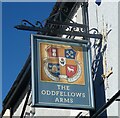
Sign of The Oddfellows Arms
Sign for The Oddfellows Arms Image
Image: © Gerald England
Taken: 18 Oct 2022
0.06 miles