IMAGES TAKEN NEAR TO
South Railway Street, SEAHAM, SR7 7EN
Introduction
This page details the photographs taken nearby to South Railway Street, SR7 7EN by members of the Geograph project.
The Geograph project started in 2005 with the aim of publishing, organising and preserving representative images for every square kilometre of Great Britain, Ireland and the Isle of Man.

There are currently over 7.5m images from over14,400 individuals and you can help contribute to the project by visiting https://www.geograph.org.uk
Image Map
Images are licensed for reuse under creativecommons.org/licenses/by-sa/2.0
Notes
- Clicking on the map will re-center to the selected point.
- The higher the marker number, the further away the image location is from the centre of the postcode.
Image Listing (94 Images Found)
Images are licensed for reuse under creativecommons.org/licenses/by-sa/2.0
Image
Details
Distance
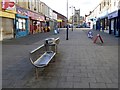
1
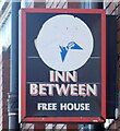
Sign of the Inn Between
Sign for the Inn Between Image
Image: © Gerald England
Taken: 18 Oct 2022
0.03 miles
2
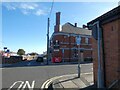
The Inn Between
On the corner of South Railway Street and Adelaide Row. Originally a Newcastle Breweries pub and previously named the Masons Arms (1831-1861) and Northumberland Arms. It acquired the name The Inn Between in the 1980s. It was refurbished and opened up in 2020 after being closed and boarded up for ten years.
Image
Image: © Gerald England
Taken: 18 Oct 2022
0.03 miles
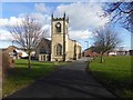
3
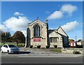
Seaham, St John's parish church
Wider view showing location of benchmark - 1914 OS map indicates 98ft above sea level.
Image: © Mel Towler
Taken: 15 May 2021
0.04 miles
4
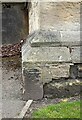
Seaham, St John's parish church
Benchmark on stonework. OS 1914 map says 98ft above sea level.
Image: © Mel Towler
Taken: 15 May 2021
0.04 miles
5
Church Street, Seaham
Pedestrianised street leading from the Harbour up to St John's Parish Church.
Image: © Oliver Dixon
Taken: 10 Feb 2016
0.06 miles
6
Church of St John the Evangelist
The parish Church of Seaham, grade 2 listed, dating from 1835-40 with more recent additions.
Image: © Oliver Dixon
Taken: 10 Feb 2016
0.07 miles
7
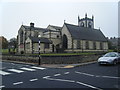
Seaham Parish Church, St John the Evangelist
Image: © Colin Pyle
Taken: 3 Nov 2015
0.07 miles
8
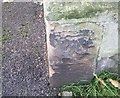
Ordnance Survey Cut Mark
This OS cut mark can be found on the north face of St John's Church. It marks a point 29.608m above mean sea level.
Image: © Adrian Dust
Taken: 19 Sep 2018
0.07 miles
9
Parish Church of St John the Evangelist, Seaham
The Grade II listed https://historicengland.org.uk/listing/the-list/list-entry/1277262?section=official-list-entry church by Thomas Prosser dates from 1840. The north aisle was added in 1860 and the choir and vicar's vestries were added by R.J.Johnson in 1885-6.
An historic timeline can be found on the church website: https://stjohns-seaham.org.uk/church-history
Image: © Gerald England
Taken: 18 Oct 2022
0.07 miles
10
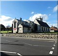
Parish Church of St John the Evangelist, Seaham
The Grade II listed https://historicengland.org.uk/listing/the-list/list-entry/1277262?section=official-list-entry church by Thomas Prosser dates from 1840. The north aisle was added in 1860 and the choir and vicar's vestries were added by R.J.Johnson in 1885-6.
An historic timeline can be found on the church website: https://stjohns-seaham.org.uk/church-history
Image: © Gerald England
Taken: 18 Oct 2022
0.07 miles