IMAGES TAKEN NEAR TO
Claremont Road, SUNDERLAND, SR6 9DP
Introduction
This page details the photographs taken nearby to Claremont Road, SR6 9DP by members of the Geograph project.
The Geograph project started in 2005 with the aim of publishing, organising and preserving representative images for every square kilometre of Great Britain, Ireland and the Isle of Man.

There are currently over 7.5m images from over14,400 individuals and you can help contribute to the project by visiting https://www.geograph.org.uk
Image Map
Images are licensed for reuse under creativecommons.org/licenses/by-sa/2.0
Notes
- Clicking on the map will re-center to the selected point.
- The higher the marker number, the further away the image location is from the centre of the postcode.
Image Listing (118 Images Found)
Images are licensed for reuse under creativecommons.org/licenses/by-sa/2.0
Image
Details
Distance
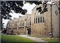
1
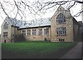
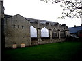
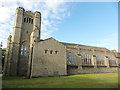
Priestman Hall, Roker
Linked to St Andrew's Church (off right).
Image: © Stanley Howe
Taken: 16 Apr 2011
0.01 miles
2
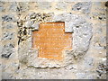
Foundation Stone of Priestman Hall
Laid by Lady Priestman on 30th July 1928.
Image: © Stanley Howe
Taken: 16 Apr 2011
0.01 miles
4
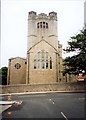
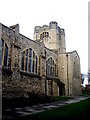
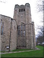
St Andrew, Roker
Built in 1905 in the Arts and Crafts style with windows by Burne-Jones and carpet by Wm Morris.
Image: © Stanley Walker
Taken: Unknown
0.02 miles
5
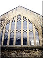
Great West Window of St Andrew's Roker
Image: © Stanley Howe
Taken: 16 Apr 2011
0.02 miles