1
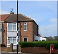
Dykelands Road, Seaburn, Sunderland
Semi-detached inter war houses on Dykelands Road in the Seaburn area of Sunderland.
Image: © Graham Robson
Taken: 23 Sep 2018
0.08 miles
2
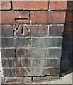
75 Dykelands Road, Seaburn
According to the OS benchmark database there is a benchmark cut into the north-east face of the property. Nothing could be seen from the roadside.
Image: © Mel Towler
Taken: 26 Apr 2023
0.08 miles
3
Deepdene Road, Seaburn, Sunderland
A residential street off Deepdyke Road in Seaburn.
Image: © Graham Robson
Taken: 23 Sep 2018
0.08 miles
4
Bee-eater in Seaburn, Sunderland
A vagrant from Southern Europe/Northern Africa
Image: © Les Hull
Taken: 10 Nov 2012
0.09 miles
5
Seaburn, Fulwell Junior School
According to the OS benchmark database there is a benchmark cut into the west face of the building. No access was possible to make a search.
Image: © Mel Towler
Taken: 26 Apr 2023
0.10 miles
6
Mitford Street, SR6
Image: © Mike Quinn
Taken: 7 Aug 2014
0.11 miles
7
Sunderland Flying Boat Public House
Now named The Royal Marine, which was its original name when first opened right next to Fulwell Junior School. Many locals graduated from both.
Image: © R J McNaughton
Taken: 24 Jul 2004
0.13 miles
8
Roadside wall, Sea Road, Seaburn
There is a benchmark cut into the brick built post at the corner angle, and the mark faces south onto Sea Road, Seaburn. Closer view
Image]
Image: © Mel Towler
Taken: 26 Apr 2023
0.13 miles
9
Benchmark in roadside wall, Sea Road, Seaburn
The benchmark is cut into a brick built post and faces south onto Sea Road, Seaburn. Wider view
Image]
Image: © Mel Towler
Taken: 26 Apr 2023
0.14 miles
10
43 Dykelands Road, Seaburn
According to the OS benchmark database there is a benchmark cut into the north-east face of the property. A new garage extension has been built and it is unlikely the cutmark remains.
Image: © Mel Towler
Taken: 26 Apr 2023
0.14 miles


