IMAGES TAKEN NEAR TO
Thirlmere, SUNDERLAND, SR6 7QG
Introduction
This page details the photographs taken nearby to Thirlmere, SR6 7QG by members of the Geograph project.
The Geograph project started in 2005 with the aim of publishing, organising and preserving representative images for every square kilometre of Great Britain, Ireland and the Isle of Man.

There are currently over 7.5m images from over14,400 individuals and you can help contribute to the project by visiting https://www.geograph.org.uk
Image Map
Images are licensed for reuse under creativecommons.org/licenses/by-sa/2.0
Notes
- Clicking on the map will re-center to the selected point.
- The higher the marker number, the further away the image location is from the centre of the postcode.
Image Listing (39 Images Found)
Images are licensed for reuse under creativecommons.org/licenses/by-sa/2.0
Image
Details
Distance
1
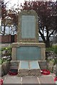
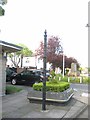
War memorial, Cleadon
The war memorial located in the middle of Cleadon on Front Street. The two main plaques on the memorial can be seen more closely in Image and Image
Image: © Graham Robson
Taken: 23 Sep 2018
0.09 miles
2
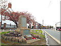
War memorial, Cleadon
A war memorial in the village of Cleadon, in South Tyneside.
Image: © Malc McDonald
Taken: 4 Apr 2015
0.09 miles
3
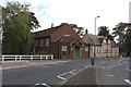
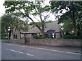
All Saints Parish Hall, Cleadon
The parish hall located in the middle of the village of Cleadon.
Image: © Graham Robson
Taken: 23 Sep 2018
0.10 miles
4
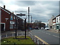
Front Street, Cleadon
With a village name sign for anyone turning off the A1018.
Image: © Christine Johnstone
Taken: 25 Feb 2017
0.10 miles
5
Front Street, Cleadon
Front Street in the village of Cleadon, in South Tyneside. The earliest recorded mention of the village is in the Boldon Buke of 1183. This is marked on the village sign, commemorating 800 years of the village in 1983.
Image: © Malc McDonald
Taken: 4 Apr 2015
0.10 miles
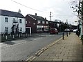
6
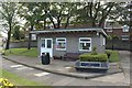
Cleadon Village Community Room
A small building containing a space which is available for community use. It is located close to the road junction in the centre of the village.
Image: © Graham Robson
Taken: 23 Sep 2018
0.10 miles
7
Old Direction Sign - Signpost by Front Street, Cleadon
Cone on ball finial - no arms; by the UC road, in parish of Sunderland (Sunderland District), Cleadon Front Street, junction with A1018, Shields Road, in front of community building.
Missing by May 2018, Streetview.
To be surveyed
Milestone Society National ID: DU_NZ3862
Image: © Milestone Society
Taken: Unknown
0.10 miles
8
All Saints Church
In the village of Cleadon. The church dates from 1869, although the village itself is far older and is mentioned in the Boldon Book of 1180. However previous to 1869 the village formed part of the parish of Whitburn, the larger village on the coast nearby.
Image: © Robert Graham
Taken: 9 Aug 2011
0.10 miles
9
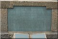
Second World War commemoration plaque, Cleadon war memorial
This plaque contains the names of members of the armed forces from Cleadon who gave their lives during the fighting of the Second World War. The whole memorial can be seen in Image
Image: © Graham Robson
Taken: 23 Sep 2018
0.10 miles
10
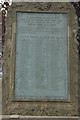
First World War plaque, Cleadon war memorial
This inscribed plaque on the war memorial in Cleadon gives the names of all the men who gave their lives for the country in the First World War. The whole memorial can be seen in Image
Image: © Graham Robson
Taken: 23 Sep 2018
0.10 miles