IMAGES TAKEN NEAR TO
Buckingham Close, SUNDERLAND, SR6 7AX
Introduction
This page details the photographs taken nearby to Buckingham Close, SR6 7AX by members of the Geograph project.
The Geograph project started in 2005 with the aim of publishing, organising and preserving representative images for every square kilometre of Great Britain, Ireland and the Isle of Man.

There are currently over 7.5m images from over14,400 individuals and you can help contribute to the project by visiting https://www.geograph.org.uk
Image Map
Images are licensed for reuse under creativecommons.org/licenses/by-sa/2.0
Notes
- Clicking on the map will re-center to the selected point.
- The higher the marker number, the further away the image location is from the centre of the postcode.
Image Listing (73 Images Found)
Images are licensed for reuse under creativecommons.org/licenses/by-sa/2.0
Image
Details
Distance
1
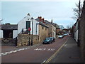
North Guards, Whitburn
North Guards is a road in the village of Whitburn. The red circular no entry sign indicates that it is a one-way street.
Image: © Malc McDonald
Taken: 4 Apr 2015
0.06 miles

9
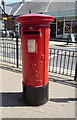
Elizabeth II postbox on East Street, Whitburn
outside the Post Office.
Postbox No. SR6 171.
See Image] for context.
Image: © JThomas
Taken: 7 Jul 2018
0.09 miles
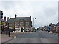
10
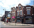
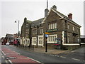
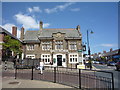
Post office and shops on East Street, Whitburn
Showing position of Postbox No. SR6 171
See Image] for postbox.
Image: © JThomas
Taken: 7 Jul 2018
0.10 miles